This article needs additional citations for verification. (June 2013) |
 | |
|---|---|
| Central Avenue | |
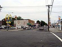
 Looking east at Springfield Boulevard in Cambria Heights | |
| Maintained by | NYCDOT and NCDPW |
| Length | 12.7 mi (20.4 km)[1][1][2] Combined length of three segments |
| Component highways | |
| Location | Brooklyn and Queens |
| West end | Flatbush Avenue in Flatbush |
| Major junctions | |
| East end | |
Linden Boulevard is a boulevard in New York City and Nassau County. Its western end is at Flatbush Avenue in Brooklyn, where Linden Boulevard travels as an eastbound-only street to Caton Avenue, where it becomes a two-way street. The boulevard stretches through both Brooklyn and Queens – in addition to southwestern Nassau County. This boulevard, especially the area of Cambria Heights between Springfield Boulevard and the Nassau County line represents a smaller version of shopping centers located on Jamaica Avenue and Queens Boulevard.
Within Nassau County, the road becomes the unsigned Nassau County Route C36. It is known as Linden Boulevard as far east as Valley Stream and then becomes Central Avenue, which was one of several former names of the street in Queens.
- ^ a b "Linden Boulevard" (Map). Google Maps. Google. July 2, 2018. Retrieved July 2, 2018.
- ^ "Linden Boulevard" (Map). Google Maps. Google. July 2, 2018. Retrieved July 2, 2018.
© MMXXIII Rich X Search. We shall prevail. All rights reserved. Rich X Search
