Back Lindfield (bahin nga lungsod) CEB لیندفیلد، نیو ساوت ولز Persian Lindfield (Australie) French Lindfield, New South Wales Romanian Lindfield (del av en befolkad plats) Swedish لنڈ فیلڈ، نیوساؤتھ ویلز Urdu
| Lindfield Sydney, New South Wales | |||||||||||||||
|---|---|---|---|---|---|---|---|---|---|---|---|---|---|---|---|
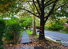
 Waimea Road | |||||||||||||||
 | |||||||||||||||
| Population | 10,943 (SAL 2021)[1] | ||||||||||||||
| Established | 1815 | ||||||||||||||
| Postcode(s) | 2070 | ||||||||||||||
| Elevation | 106 m (348 ft) | ||||||||||||||
| Area | 5.17 km2 (2.0 sq mi)[2] | ||||||||||||||
| Location | 13 km (8 mi) north-west of Sydney CBD | ||||||||||||||
| LGA(s) | Ku-ring-gai Council | ||||||||||||||
| State electorate(s) | |||||||||||||||
| Federal division(s) | Bradfield | ||||||||||||||
| |||||||||||||||
Lindfield is a suburb on the Upper North Shore of Sydney in the state of New South Wales, Australia. It is 13 kilometres north-west of the Sydney Central Business District and is in the local government area of Ku-ring-gai Council. East Lindfield is a separate suburb to the east, sharing the postcode of 2070.
This suburb of 5.17 square kilometres contains residential housing of California bungalow and federation style, in double brick and tile construction. Australian native bushland in Garigal National Park and Lane Cove National Park borders the suburb.
- ^ Australian Bureau of Statistics (28 June 2022). "Lindfield (suburb and locality)". Australian Census 2021 QuickStats. Retrieved 28 June 2022.
- ^ "Basic Community Profile (spreadsheet)". Australian Bureau of Statistics. Retrieved 26 April 2014.
© MMXXIII Rich X Search. We shall prevail. All rights reserved. Rich X Search