Back مضيق لومبوك Arabic Lombok boğazı Azerbaijani Selat Lombok BAN Estret de Lombok Catalan Selat Lombok CEB Lombocký průliv Czech Lombokstrædet Danish Lombokstraße German Lomboka Markolo Esperanto Estrecho de Lombok Spanish
| Lombok Strait | |
|---|---|
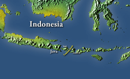
 Map locating the Lombok Strait | |
| Coordinates | 8°46′S 115°44′E / 8.767°S 115.733°E |
| Type | Strait |
| Ocean/sea sources | Indian Ocean and Bali Sea |
| Basin countries | Indonesia |
| Max. length | 60 km (37 mi) |
| Max. width | 40 km (25 mi) |
| Min. width | 20 km (12 mi) |
| Average depth | 250 m (820 ft) |
| Islands | Bali Nusa Penida |
The Lombok Strait (Indonesian: Selat Lombok), is a strait of the Bali Sea connecting to the Indian Ocean, and is located between the islands of Bali and Lombok in Indonesia. The Gili Islands are on the Lombok side.
Its narrowest point is at its southern opening, with a width of about 20 km (12 miles) between the islands of Lombok and Nusa Penida, in the middle of the strait. At the northern opening, it is 40 km (25 miles) across. Its total length is about 60 km (37 miles). As it is minimum 250 m (820 feet) deep[1] — much deeper than the Strait of Malacca — ships that draw too much water to pass through the Malacca Strait (so-called "post Malaccamax" vessels) often use the Lombok Strait, instead.
The Lombok Strait is notable as one of the main passages for the Indonesian Throughflow (ITF) that exchanges water between the Indian Ocean and the Pacific Ocean.[2]
It is also part of the biogeographical boundary between the fauna of the Indomalayan realm and the distinctly different fauna of Australasia. The boundary is known as the Wallace Line, for Alfred Russel Wallace, who first remarked upon the striking difference between animals of Indomalaya and those of Australasia, and how abrupt the boundary was between the two biomes.[3]
Biologists believe it was the depth of the Lombok Strait itself that kept the animals on either side isolated from one another.[4] When sea levels dropped during the Pleistocene ice age, the islands of Bali, Java and Sumatra were all connected to one another and to the mainland of Asia.[4] They shared the Asian fauna. The Lombok Strait's deep water kept Lombok and the Lesser Sunda archipelago isolated from the Asian mainland. These islands were, instead, colonised by Australasian fauna.[5]
- ^ Susanto, R. Dwi; Leonid Mitnik; Quanan Zheng (December 2005). "Ocean Internal Waves Observed in the Lombok Strait" (PDF). Oceanography. 18 (4): 83. doi:10.5670/oceanog.2005.08. Archived from the original (PDF) on 9 October 2011. Retrieved 16 May 2008.
- ^ sydney.primo.exlibrisgroup.com https://sydney.primo.exlibrisgroup.com/discovery/fulldisplay?&context=PC&vid=61USYD_INST:sydney&docid=cdi_iop_journals_10_1088_1755_1315_618_1_012014. Retrieved 2021-05-17.
{{cite web}}: Missing or empty|title=(help) - ^ Van Oosterzee, Penny (1997). Where worlds collide : the Wallace line. Kew, Vic.: Reed. ISBN 0-7301-0470-2. OCLC 38218451.
- ^ a b aresetar (2011-01-12). "Pleistocene Sea Level Maps". Field Museum. Retrieved 2021-05-31.
- ^ Dawkins, Richard (2005). The ancestor's tale : a pilgrimage to the dawn of life. Yan Wong. London: Phoenix. ISBN 978-0-7538-1996-8. OCLC 60794544.
© MMXXIII Rich X Search. We shall prevail. All rights reserved. Rich X Search
