Back Lommel Afrikaans لمل Arabic Ломел Bulgarian Lommel Breton Lommel Catalan Lommel (parokya) CEB Lommel Danish Lommel German Lommel Esperanto Lommel Spanish
Lommel | |
|---|---|
City and municipality | |
 St. Peter in Chains Church | |
| Coordinates: 51°14′N 05°18′E / 51.233°N 5.300°E | |
| Country | |
| Community | Flemish Community |
| Region | Flemish Region |
| Province | Limburg |
| Arrondissement | Maaseik |
| Government | |
| • Mayor | Bob Nijs (CD&V) |
| • Governing party/ies | CD&V, NV-A |
| Area | |
| • Total | 102.28 km2 (39.49 sq mi) |
| Population (2018-01-01)[1] | |
| • Total | 34,044 |
| • Density | 330/km2 (860/sq mi) |
| Postal codes | 3920 |
| NIS code | 72020 |
| Area codes | 011 |
| Website | www.lommel.be |
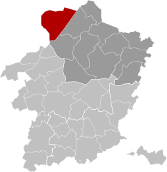
Lommel (Dutch pronunciation: [ˈlɔməl]) is a municipality and a city in the Belgian province of Limburg. The Kempen city has about 34,000 inhabitants and is part of the electoral district and the judicial district Lommel Neerpelt.
Besides residential town of Lommel also has a number of nature reserves, such as the nature reserve De Watering, the Lommel Sahara, and numerous forests and heathlands. Lommel is the third shopping city in Belgian Limburg with a commercial and shopping center De Singel. Importantly, the silver sand that is mined here for the benefit of the glass industry. Some sand mining quarries are transformed into nature reserves and recreational areas, including Lommel Sahara.
The city of Lommel is the watershed of the basins of the Scheldt, and Meuse, and within these basins Nete Dommel respectively.
- ^ "Wettelijke Bevolking per gemeente op 1 januari 2018". Statbel. Retrieved 9 March 2019.
© MMXXIII Rich X Search. We shall prevail. All rights reserved. Rich X Search


