| Lower Mississippi River | |
|---|---|
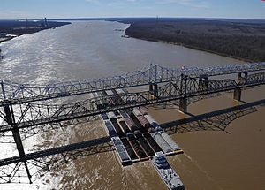
 35 barges passing under the Vicksburg Bridge by Vicksburg, Miss. | |
| Location | |
| Country | US |
| Physical characteristics | |
| Source | |
| • location | Cairo, Illinois (confluence of Ohio River and Upper Mississippi River) |
| • elevation | 315 ft (96 m) |
| Mouth | |
• location | Gulf of Mexico |
| Length | 990 mi (1,600 km) |

The Lower Mississippi River is the portion of the Mississippi River downstream of Cairo, Illinois. From the confluence of the Ohio River and Upper Mississippi River at Cairo, the Lower flows just under 1000 miles (1600 km) to the Gulf of Mexico.[1] It is the most heavily travelled component of the Mississippi River System.[2]
- ^ Bragg, Marion (1977). Names and Places on the Mississippi River. Vicksburg: Mississippi River Commission. Archived from the original on 2006-01-28.
- ^ "Waterborne Commerce Statistics Center". Navigation Data Center. Archived from the original on 2006-02-08. Retrieved 2006-03-12.
© MMXXIII Rich X Search. We shall prevail. All rights reserved. Rich X Search
