Back Lubuagan BCL Lubuagan CBK-ZAM Lubuagan CEB Lubuagan German Lubuagan Spanish Lubuagan French Lubuagan ID Lubuagan ILO Lubuagan Italian ლუბუაგანი Georgian
This article needs additional citations for verification. (January 2014) |
Lubuagan | |
|---|---|
| Municipality of Lubuagan | |
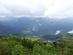
 Lubuagan from the Magmag-an Pass | |
 Map of Kalinga with Lubuagan highlighted | |
Location within the Philippines | |
| Coordinates: 17°21′N 121°11′E / 17.35°N 121.18°E | |
| Country | Philippines |
| Region | Cordillera Administrative Region |
| Province | Kalinga |
| District | Lone district |
| Founded | 1905 |
| Barangays | 9 (see Barangays) |
| Government | |
| • Type | Sangguniang Bayan |
| • Mayor | Joel B. Tagaotao |
| • Vice Mayor | Alonzo C. Saclag Jr. |
| • Representative | Allen Jesse C. Mangaoang |
| • Municipal Council | Members |
| • Electorate | 10,344 voters (2022) |
| Area | |
| • Total | 234.20 km2 (90.43 sq mi) |
| Elevation | 820 m (2,690 ft) |
| Highest elevation | 1,880 m (6,170 ft) |
| Lowest elevation | 348 m (1,142 ft) |
| Population (2020 census)[3] | |
| • Total | 9,323 |
| • Density | 40/km2 (100/sq mi) |
| • Households | 1,982 |
| Economy | |
| • Income class | 4th municipal income class |
| • Poverty incidence | 7.52 |
| • Revenue | ₱ 99.43 million (2020) |
| • Assets | ₱ 251.3 million (2020) |
| • Expenditure | ₱ 72.68 million (2020) |
| • Liabilities | ₱ 59.2 million (2020) |
| Service provider | |
| • Electricity | Kalinga - Apayao Electric Cooperative (KAELCO) |
| Time zone | UTC+8 (PST) |
| ZIP code | 3802 |
| PSGC | |
| IDD : area code | +63 (0)74 |
| Native languages | Ilocano Tagalog |
| Website | www |
Lubuagan, officially the Municipality of Lubuagan is a 4th class municipality in the province of Kalinga, Philippines. According to the 2020 census, it has a population of 9,323 people.[3]
Lubuagan is 43 kilometres (27 mi) from Tabuk City and 457 kilometres (284 mi) from Manila.
Lubuagan Municipality, once the seat of the National Government from March 6 to May 17, 1900, during the time of Gen. Emilio Aguinaldo, was among the eight (8) municipalities of the new province of Kalinga. It is located at 800 metres (2,600 ft) above sea level in the southern part of Kalinga and in the heart of the Cordillera. It has a land area of 23,420 hectares (57,900 acres). Some of its younger generation have migrated either in the lowland plains of Tabuk or in other provinces in search for income and employment opportunities.
- ^ Municipality of Lubuagan | (DILG)
- ^ "2015 Census of Population, Report No. 3 – Population, Land Area, and Population Density" (PDF). Philippine Statistics Authority. Quezon City, Philippines. August 2016. ISSN 0117-1453. Archived (PDF) from the original on May 25, 2021. Retrieved July 16, 2021.
{{cite web}}: CS1 maint: year (link) - ^ a b Census of Population (2020). "Cordillera Administrative Region (CAR)". Total Population by Province, City, Municipality and Barangay. Philippine Statistics Authority. Retrieved 8 July 2021.
- ^ "PSA Releases the 2021 City and Municipal Level Poverty Estimates". Philippine Statistics Authority. 2 April 2024. Retrieved 28 April 2024.
© MMXXIII Rich X Search. We shall prevail. All rights reserved. Rich X Search


