Back مقاطعة ماديسون Arabic مادیسون بؤلگهسی، ایندیانا AZB Madison County, Indiana BAR Медисън (окръг, Индиана) Bulgarian মেডিশন কাউন্টি, ইন্ডিয়ানা BPY Madison Gông (Indiana) CDO Мадисон (гуо, Индиана) CE Madison County (kondado sa Tinipong Bansa, Indiana) CEB Madison County, Indiana Welsh Madison County (Indiana) German
Madison County | |
|---|---|
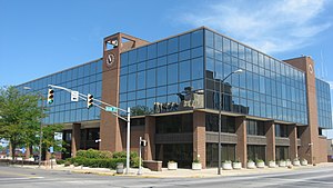
 Madison County Courthouse in Anderson | |
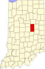
 Location within the U.S. state of Indiana | |
 Indiana's location within the U.S. | |
| Coordinates: 40°10′N 85°43′W / 40.16°N 85.72°W | |
| Country | |
| State | |
| Founded | January 4, 1823 (authorized) |
| Named for | James Madison |
| Seat | Anderson |
| Largest city | Anderson |
| Area | |
| • Total | 452.90 sq mi (1,173.0 km2) |
| • Land | 451.92 sq mi (1,170.5 km2) |
| • Water | 0.99 sq mi (2.6 km2) 0.22% |
| Population (2020) | |
| • Total | 130,129 |
| • Density | 286.7/sq mi (110.7/km2) |
| Time zone | UTC−5 (Eastern) |
| • Summer (DST) | UTC−4 (EDT) |
| Congressional district | 5th |
| Website | www |
| Indiana county number 48 | |
Madison County is a county in the U.S. state of Indiana. The 2020 census states the population is standing at 130,129.[1] The county seat since 1836 has been Anderson,[2][3] one of three incorporated cities within the county.
Madison County is included in the Indianapolis-Carmel-Anderson, IN Metropolitan Statistical Area.
- ^ "American FactFinder". US Census Bureau. US Census Bureau. Archived from the original on February 14, 2020. Retrieved January 29, 2022.
- ^ "Find a County". National Association of Counties. Retrieved June 7, 2011.
- ^ Harden (1874), p. 23
© MMXXIII Rich X Search. We shall prevail. All rights reserved. Rich X Search