Back مقاطعة ماديسون (لويزيانا) Arabic Madison Parish, Louisiana BAR মেডিশন পারিশ, লুইসিয়ানা BPY Madison Gông (Louisiana) CDO Мэдисон (кӀошт, Луизиана) CE Madison Parish CEB Madison Parish, Louisiana Welsh Madison Parish German Parroquia de Madison Spanish Madisoni vald Estonian
Madison Parish | |
|---|---|
 Madison Parish Courthouse in Tallulah | |
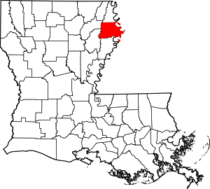
 Location within the U.S. state of Louisiana | |
 Louisiana's location within the U.S. | |
| Coordinates: 32°22′N 91°14′W / 32.37°N 91.24°W | |
| Country | |
| State | |
| Founded | 1838 |
| Named for | James Madison |
| Seat | Tallulah |
| Largest city | Tallulah |
| Area | |
| • Total | 651 sq mi (1,690 km2) |
| • Land | 624 sq mi (1,620 km2) |
| • Water | 26 sq mi (70 km2) 4.1% |
| Population (2020) | |
| • Total | 10,017 |
| • Density | 15/sq mi (5.9/km2) |
| Time zone | UTC−6 (Central) |
| • Summer (DST) | UTC−5 (CDT) |
| Congressional district | 5th |
| Website | madisonparish |


Madison Parish (French: Paroisse de Madison) is a parish located on the northeastern border of the U.S. state of Louisiana, in the delta lowlands along the Mississippi River. As of the 2020 census, the population was 10,017.[1] Its parish seat is Tallulah.[2] The parish was formed in 1839.[3]
With a history of cotton plantations and pecan farms, the parish economy continues to be primarily agricultural. It has a majority African-American population. For years a ferry connected Delta, Louisiana (and traffic from the parish) to Vicksburg, Mississippi. The Vicksburg Bridge now carries U.S. Route 80 and Interstate 20 across the river into Madison Parish.
- ^ "Census - Geography Profile: Madison Parish, Louisiana". United States Census Bureau. Retrieved January 22, 2023.
- ^ "Find a County". National Association of Counties. Archived from the original on May 31, 2011. Retrieved June 7, 2011.
- ^ "Madison Parish". Center for Cultural and Eco-Tourism. Archived from the original on September 8, 2008. Retrieved September 5, 2014.
© MMXXIII Rich X Search. We shall prevail. All rights reserved. Rich X Search