Magic Valley | |
|---|---|
Region | |
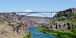
 Perrine Bridge spanning the Snake River Canyon at Twin Falls. | |
 Map of Idaho highlighting counties in the Magic Valley region. | |
| Country | |
| State | |
| Largest city | Twin Falls (pop.: 44,125) |
| Population (2010) | |
| • Total | 185,790 |
| Time zone | UTC−7 (Mountain) |
| • Summer (DST) | UTC−6 (MDT) |
| Area code(s) | 208, 986 |
The Magic Valley, also known as South Central Idaho, is a region in south-central Idaho constituting Blaine, Camas, Cassia, Gooding, Jerome, Lincoln, Minidoka, and Twin Falls counties. It is particularly associated with the agricultural region in the Snake River Plain located in the area.[1] The northern Magic Valley region — particularly Blaine and Camas Counties — is also known as the Wood River Valley after the Big Wood River.
- ^ Wright, Samantha (September 19, 2016). "Watering Idaho: The Snake River Plain Aquifer". Boise State Public Radio. Retrieved May 29, 2018.
© MMXXIII Rich X Search. We shall prevail. All rights reserved. Rich X Search
