Back মাগুরা জেলা Bengali/Bangla মাগুরা জিলা BPY Magura (distrito) CEB Magura (Distrikt) German Magura (zila) Spanish ناحیه ماگورا Persian Magura (district) French मगुरा जिला Hindi Magura District HIF Distretto di Magura Italian
This article needs additional citations for verification. (October 2009) |
Magura district
মাগুরা | |
|---|---|
 Binodpur B.K. Secondary School | |
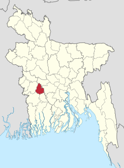
 Location of Magura District in Bangladesh | |
 Expandable map of Magura District | |
| Coordinates: 23°24′N 89°24′E / 23.40°N 89.40°E | |
| Country | |
| Division | Khulna |
| Headquarters | Magura |
| Government | |
| • Deputy Commissioner | Mohammad Abu Naser Beg |
| Area | |
| • Total | 1,039.10 km2 (401.20 sq mi) |
| Population | |
| • Total | 1,033,115 |
| • Density | 990/km2 (2,600/sq mi) |
| Time zone | UTC+06:00 (BST) |
| Postal code | 7600 |
| HDI (2019) | 0.660[2] medium · 2nd of 20 |
Magura District (Bengali: মাগুরা) is a district in southwestern Bangladesh, situated 176 kilometers from Dhaka. It is a part of Khulna Division.[3]
- ^ Cite error: The named reference
2022censuswas invoked but never defined (see the help page). - ^ "Sub-national HDI - Area Database - Global Data Lab". hdi.globaldatalab.org. Retrieved 2020-03-18.
- ^ Abu Naser Majnu (2012). "Magura District". In Sirajul Islam and Ahmed A. Jamal (ed.). Banglapedia: National Encyclopedia of Bangladesh (Second ed.). Asiatic Society of Bangladesh.
© MMXXIII Rich X Search. We shall prevail. All rights reserved. Rich X Search