Back ميتلاند Arabic ميتلاند ARZ میتلند، فلوریدا AZB Maitland (Florida) Catalan Мейтленд (Флорида) CE Maitland (lungsod sa Tinipong Bansa, Florida) CEB Maitland, Florida Welsh Maitland (Florida) German Maitland (Florida) Spanish Maitland (Florida) Basque
Maitland, Florida | |
|---|---|
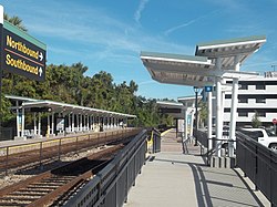
 Maitland station | |
| Motto: A Community For Life | |
 | |
 U.S. Census map | |
| Coordinates: 28°37′37″N 81°22′01″W / 28.62694°N 81.36694°W | |
| Country | |
| State | |
| County | Orange |
| Incorporated (Town) | July 17, 1885 |
| Incorporated (City) | June 1, 1959 |
| Area | |
| • Total | 6.48 sq mi (16.78 km2) |
| • Land | 5.36 sq mi (13.88 km2) |
| • Water | 1.12 sq mi (2.89 km2) |
| Elevation | 75 ft (23 m) |
| Population (2020) | |
| • Total | 19,543 |
| • Estimate (2021)[3] | 18,959 |
| • Density | 3,646.08/sq mi (1,407.78/km2) |
| Time zone | UTC-5 (Eastern (EST)) |
| • Summer (DST) | UTC-4 (EDT) |
| ZIP codes | 32751, 32794 |
| Area code(s) | 407, 689 |
| FIPS code | 12-42575[4] |
| GNIS feature ID | 2405000[2] |
| Website | www |
Maitland is a suburban city in Orange County, Florida, United States, part of the Greater Orlando area. The population was 19,543 at the 2020 census.[5] The area's history is exhibited at the Maitland Historical Museum; the city also hosts the Maitland Art Center, as well as notable examples of Mayan Revival architecture and Fantasy architecture, the Maitland Telephone Museum, and the William H. Waterhouse House Museum (all museums and the Maitland Art Center are now managed by Art & History Museums of Maitland). A SunRail station is located in Maitland on Highway 17–92. The city is named for Fort Maitland.
- ^ "2020 U.S. Gazetteer Files". United States Census Bureau. Retrieved October 31, 2021.
- ^ a b U.S. Geological Survey Geographic Names Information System: Maitland, Florida
- ^ "Population and Housing Unit Estimates". United States Census Bureau. July 1, 2021. Retrieved April 20, 2023.
- ^ "U.S. Census website". United States Census Bureau. Retrieved January 31, 2008.
- ^ "Census.gov Quick Facts Maitland city, Florida". Census.gov. Retrieved April 20, 2023.
© MMXXIII Rich X Search. We shall prevail. All rights reserved. Rich X Search
