Back Maleny CEB ملانی، کوئینزلند Persian Maleny French Maleny Malagasy Maleny Polish Maleny, Queensland Swedish
| Maleny Queensland | |||||||||||||||
|---|---|---|---|---|---|---|---|---|---|---|---|---|---|---|---|
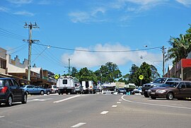
 Main street of Maleny | |||||||||||||||
| Coordinates | 26°45′29″S 152°51′05″E / 26.7580°S 152.8513°E | ||||||||||||||
| Population | 3,959 (2021 census)[1] | ||||||||||||||
| • Density | 159.0/km2 (411.8/sq mi) | ||||||||||||||
| Postcode(s) | 4552 | ||||||||||||||
| Elevation | 425 m (1,394 ft) | ||||||||||||||
| Area | 24.9 km2 (9.6 sq mi) | ||||||||||||||
| Time zone | AEST (UTC+10:00) | ||||||||||||||
| Location |
| ||||||||||||||
| LGA(s) | Sunshine Coast Region | ||||||||||||||
| State electorate(s) | Glass House | ||||||||||||||
| Federal division(s) | Fisher | ||||||||||||||
| |||||||||||||||
| |||||||||||||||


Maleny (pronounced muh-LAY-knee) is a rural town and locality in the Sunshine Coast Region, Queensland, Australia.[2][3] Maleny was a timber town until the early 1920s and then was a centre of dairy production and fruit growing.[4] In the 2021 census, the locality of Maleny had a population of 3,959 people.[1]
- ^ a b Cite error: The named reference
Census2021was invoked but never defined (see the help page). - ^ "Maleny – town in Sunshine Coast Region (entry 20710)". Queensland Place Names. Queensland Government. Retrieved 29 December 2020.
- ^ "Maleny – locality in Sunshine Coast Region (entry 50049)". Queensland Place Names. Queensland Government. Retrieved 29 December 2020.
- ^ Cite error: The named reference
herqldoutwas invoked but never defined (see the help page).
© MMXXIII Rich X Search. We shall prevail. All rights reserved. Rich X Search
