Back جبال ماندارا Arabic Muntanyes Mandara Catalan Mandara Mountains CEB Mandarské pohoří Czech Mandara-bjergene Danish Mandara-Gebirge German Μανταρά Greek Macizo de Mandara Spanish Monts Mandara French Duwatsun Mandara Hausa


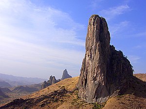
The Mandara Mountains are a volcanic range extending about 190 km (about 120 mi) along the northern part of the Cameroon–Nigeria border, from the Benue River in the south (9°18′N 12°48′E / 9.3°N 12.8°E) to the north-west of Maroua in the north (11°00′N 13°54′E / 11.0°N 13.9°E).[1] The highest elevation is the summit of Mount Oupay, at 1,494 m (4,900 ft) above sea level (10°53′N 13°47′E / 10.883°N 13.783°E).[1]
The region is densely populated, mainly by speakers of Chadic languages, including both the Mofu and the Kirdi ethnic groups.[1][2]
Extensive archaeological research has been undertaken in the Mandara Mountains, including work at Diy-Gid-Biy (DGB) sites.[3]
- ^ a b c Scheffel, Richard L.; Wernet, Susan J., eds. (1980). Natural Wonders of the World. United States of America: Reader's Digest Association, Inc. pp. 226–227. ISBN 0-89577-087-3.
- ^ "A Dormant Volcanic Range in Adamawa". Folio Nigeria. Retrieved 17 August 2020.
- ^ "Les Diy-Gid-Biy du Mont Mandara". UNESCO World Heritage List. Retrieved 29 May 2016.
© MMXXIII Rich X Search. We shall prevail. All rights reserved. Rich X Search