Back Manufaxi Azerbaijani Мануфахи Bulgarian Manufahi CEB Manufahi German Distrito de Manufahi Spanish شهرداری منوفهی Persian Manufahin alue Finnish Manufahi French Manufahi (Gemeend) FRR מנופני HE
You can help expand this article with text translated from the corresponding article in German. (July 2011) Click [show] for important translation instructions.
|
This article needs additional citations for verification. (February 2017) |
Manufahi | |
|---|---|
| |
 Landscape between Dili and Same | |
 | |
| Coordinates: 9°00′S 125°47′E / 9.000°S 125.783°E | |
| Country | |
| Capital | Same |
| Administrative posts | |
| Area | |
| • Total | 1,332.5 km2 (514.5 sq mi) |
| • Rank | 6th |
| Population (2015 census) | |
| • Total | 53,691 |
| • Rank | 11th |
| • Density | 40/km2 (100/sq mi) |
| • Rank | 11th |
| Households (2015 census) | |
| • Total | 9,023 |
| • Rank | 11th |
| Time zone | UTC+09:00 (TLT) |
| ISO 3166 code | TL-MF |
| HDI (2017) | 0.618[1] medium · 3rd |
| Website | Manufahi Municipality |
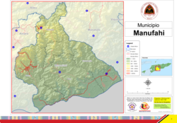
Manufahi (Portuguese: Município Manufahi, Tetum: Munisípiu Manufahi) is one of the municipalities of East Timor. It has a population of 53,691 (2015 census) and an area of 1,323 km2.[2] The capital of the municipality is Same.[3]
- ^ "Sub-national HDI - Area Database - Global Data Lab". hdi.globaldatalab.org. Retrieved 13 September 2018.
- ^ "Timor-Leste Population And Housing Census 2015". Archived from the original on 31 December 2016. Retrieved 16 February 2018.
{{cite web}}: CS1 maint: bot: original URL status unknown (link) - ^ Lansell Taudevin (1999). East Timor: Too Little Too Late. Duffy & Snellgrove. ISBN 18-759-8963-3.
© MMXXIII Rich X Search. We shall prevail. All rights reserved. Rich X Search

