Back إقليم مارا Arabic TanzaniaMaraGola AVK Мара (регион) Bulgarian Regió de Mara Catalan Mara Region CEB Mara (region) Danish Mara (Region) German Περιφέρεια Μάρα Greek Regiono Mara Esperanto Región de Mara Spanish
Mara Region
Mkoa wa Mara (Swahili) | |
|---|---|
|
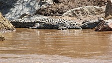
From top to bottom: Ballooning over the Serengeti in Mara, crocodile on the Mara River and Musoma city view. | |
| Nickname(s): The land of the Serengeti; Nyerere's homeland | |
 Location in Tanzania | |
| Coordinates: 1°46′31.44″S 34°9′11.52″E / 1.7754000°S 34.1532000°E | |
| Country | |
| Zone | lake |
| Capital | Musoma |
| Districts | |
| Government | |
| • Regional Commissioner | Suleiman M. Mzee (CCM) |
| Area | |
| • Total | 21,760 km2 (8,400 sq mi) |
| • Rank | 7th of 31 |
| Population (2022) | |
| • Total | 2,372,015 |
| • Rank | 10th of 31 |
| • Density | 110/km2 (280/sq mi) |
| Demonym | Maran |
| Ethnic groups | |
| • Settler | Swahili, Luo & Sukuma |
| • Native | Zanaki, Kurya, Ngurimi, Ikoma, Ikizu, Kwaya, Jita, Suba, Kerewe, Sizaki & Simbiti |
| Time zone | UTC+3 (EAT) |
| Postcode | 31xxx |
| Area code | 028 |
| ISO 3166 code | TZ-13 [1] |
| HDI (2021) | 0.541[2] low · 15th of 25 |
| Website | Official website |
| Symbols of Tanzania | |
| Bird |  |
| Butterfly | |
| Fish | |
| Mammal |  |
| Tree | |
| Mineral | |
Mara Region (Mkoa wa Mara in Swahili) is one of Tanzania's 31 administrative regions. The region covers an area of 21,760 km2 (8,400 sq mi).[3] The region is comparable in size to the combined land area of the nation state of El Salvador.[4] The neighboring regions are Mwanza Region and Simiyu Region (to the south), Arusha Region (to the southeast), and Kagera Region (across Lake Victoria). The Mara Region borders Kenya (to the northeast).The regional capital is the municipality of Musoma. Mara Region is known for being the home of Serengeti National Park, a UNESCO World Heritage site and also the birth place of Tanzania's founding father Julius Nyerere. Under British colonial occupation, the Mara Region was a district called the Lake Province, which became the Lake Region after independence in 1961.[5]
- ^ "IS0 3166". ISO. Retrieved 2022-10-09.
- ^ "Sub-national HDI - Area Database - Global Data Lab". hdi.globaldatalab.org. Archived from the original on 23 September 2018. Retrieved 2020-02-26.
- ^ "Mara Region Size".
- ^ 21,041 km2 (8,124 sq mi) for El Salvador at "Area size comparison". Nations Online. 2022. Retrieved 12 October 2022.
- ^ Cite error: The named reference
Ndembwike_08was invoked but never defined (see the help page).
© MMXXIII Rich X Search. We shall prevail. All rights reserved. Rich X Search


