Back شعبية المرج Arabic Эль-Мардж (муніцыпалітэт) BE-X-OLD Al Marj (districte) Catalan Al Marj (distrito) CEB Al Marj Danish Munizip al-Mardsch German Distrikto Al Marĝ Esperanto Distrito de Al Marj Spanish Al Marj Basque استان مرج Persian
Marj
المرج | |
|---|---|
 | |
 Map of Libya with Marj district highlighted | |
| Country | Libya |
| Capital | Marj |
| Area | |
| • Total | 10,000 km2 (4,000 sq mi) |
| Population (2006) | |
| • Total | 185,848 |
| • Density | 19/km2 (48/sq mi) |
| [1] | |
| License Plate Code | 18, 30, 52, 58 |
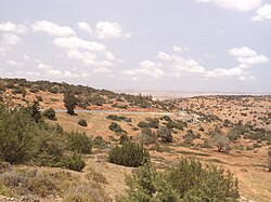
Marj (Arabic: المرج, al-Marj, "The Meadows"), pronounced El Merj in Benghazi and Egyptian Arabic, is a district (shabiyah) of northeastern Libya on the Mediterranean Sea coast. Its administrative seat is the city of Marj, which the ancient and medieval Barca. Marj is situated on the Cyrenaica Plateau at the western edge of the Jebel Akhdar. In the 2007 administrative reorganization, part of the territory formerly in Al Hizam al Akhdar District was transferred to Marj.[2] In the north, Marj has a shoreline on the Mediterranean Sea. On land, it borders Jabal al Akhdar in the east, Al Wahat in south and Benghazi in the west.
Per the census of 2012, the total population in the region was 157,747 with 150,353 Libyans. The average size of the household in the country was 6.9, while the average household size of non-Libyans being 3.7. There were totally 22,713 households in the district, with 20,907 Libyan ones. The population density of the district was 1.86 persons per km2. Per 2006 census, there were totally 13,313 economically active people in the district.
- ^ "Districts of libya". statoids.com. Retrieved 27 October 2009.
- ^ "شعبيات الجماهيرية العظمى" – "Sha'biyat of Great Jamahiriya" Archived 2009-02-07 at the Wayback Machine, Website of the General People's Committee of Libya, accessed 5 September 2009, in Arabic
© MMXXIII Rich X Search. We shall prevail. All rights reserved. Rich X Search