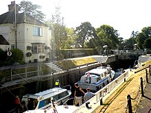
| Marlow Lock | |
|---|---|
 Marlow Lock from downstream | |
 | |
| Waterway | River Thames |
| County | Buckinghamshire |
| Maintained by | Environment Agency |
| Operation | Hydraulic |
| First built | 1773 |
| Latest built | 1927 |
| Length | 46.10 m (151 ft 3 in) [1] |
| Width | 6.07 m (19 ft 11 in)[1] |
| Fall | 2.16 m (7 ft 1 in)[1] |
| Above sea level | 88' |
| Distance to Teddington Lock | 37 miles |
Marlow Lock | |||||||||||||||||||||||||||||||||||||||||||||||||||||||||||||||||||||||||||||||||||||||||||||||||||||||||||||||||||||||
|---|---|---|---|---|---|---|---|---|---|---|---|---|---|---|---|---|---|---|---|---|---|---|---|---|---|---|---|---|---|---|---|---|---|---|---|---|---|---|---|---|---|---|---|---|---|---|---|---|---|---|---|---|---|---|---|---|---|---|---|---|---|---|---|---|---|---|---|---|---|---|---|---|---|---|---|---|---|---|---|---|---|---|---|---|---|---|---|---|---|---|---|---|---|---|---|---|---|---|---|---|---|---|---|---|---|---|---|---|---|---|---|---|---|---|---|---|---|---|---|
| |||||||||||||||||||||||||||||||||||||||||||||||||||||||||||||||||||||||||||||||||||||||||||||||||||||||||||||||||||||||


Marlow Lock is a lock and weir situated on the River Thames in the town of Marlow, Buckinghamshire, England, about 300m downstream of Marlow Bridge. The first pound lock was built by the Thames Navigation Commission in 1773.
The weir stretches a long way upstream above the lock.
- ^ a b c "Environment Agency Dimensions of locks on the River Thames". web page. Environmental Agency. 8 November 2012. Retrieved 18 November 2012. Dimensions given in metres
© MMXXIII Rich X Search. We shall prevail. All rights reserved. Rich X Search
