Back Marsfield CEB Marsfield Spanish مارسفیلد، نیو ساوت ولز Persian Marsfield Malagasy Marsfield, New South Wales Romanian Marsfield Swedish مارس فیلڈ، نیو ساؤتھ ویلز Urdu 馬斯菲爾德 Chinese
| Marsfield Sydney, New South Wales | |||||||||||||||
|---|---|---|---|---|---|---|---|---|---|---|---|---|---|---|---|
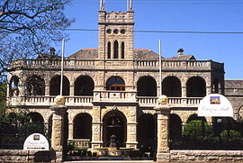
 Curzon Hall on Agincourt Road, built in 1898 | |||||||||||||||
 | |||||||||||||||
| Population | 12,492 (SAL 2021)[1] | ||||||||||||||
| Postcode(s) | 2122 | ||||||||||||||
| Elevation | 86 m (282 ft) | ||||||||||||||
| Area | 3.86 km2 (1.5 sq mi) | ||||||||||||||
| Location | 16 km (10 mi) north-west of Sydney CBD | ||||||||||||||
| LGA(s) | City of Ryde | ||||||||||||||
| State electorate(s) | Ryde | ||||||||||||||
| Federal division(s) | Bennelong | ||||||||||||||
| |||||||||||||||
Marsfield is a suburb in the Northern Sydney region of Sydney, in the state of New South Wales, Australia. Marsfield is located 16 kilometres north-west of the Sydney central business district in the local government area of the City of Ryde.[2][3]
The suburb is noted for its proximity to a number of leading scientific and tertiary educational institutions such as CSIRO, Macquarie University, the Macquarie Park Business Park and Macquarie University Hospital.
- ^ Australian Bureau of Statistics (28 June 2022). "Marsfield (suburb and locality)". Australian Census 2021 QuickStats. Retrieved 28 June 2022.
- ^ "Marsfield Upper North Shore, NSW 2122". Realestate.com.au. Retrieved 22 September 2021.
- ^ "Strategic Employment Review: Macquarie Park" (PDF). BIS Shrapnel. December 2015. Archived from the original (PDF) on 23 April 2023. Retrieved 4 March 2024 – via NSW Department of Planning and Environment.
© MMXXIII Rich X Search. We shall prevail. All rights reserved. Rich X Search