Back Sentraalmassief Afrikaans جبال الكتلة الوسطى Arabic Цэнтральны масіў Byelorussian Цэнтральны масіў BE-X-OLD Централен масив Bulgarian Torosad Kreiz Breton Centralni masiv BS Massís Septentrional Catalan Massif Central CEB Francouzské středohoří Czech
This article relies largely or entirely on a single source. (May 2019) |
| Massif Central | |
|---|---|
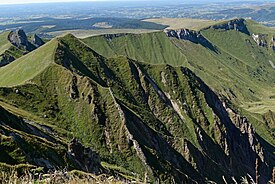
 View of Puy de Sancy, the highest peak in the Massif Central | |
| Highest point | |
| Peak | Puy de Sancy |
| Elevation | 1,886 m (6,188 ft) |
| Coordinates | 45°31′42″N 2°48′51″E / 45.52833°N 2.81417°E |
| Naming | |
| Native name | Massís Central (Occitan) |
| Pronunciation | UK: /ˌmæsiːf sɒ̃ˈtrɑːl/, US: /mæˌsiːf -, - sɛnˈ-, məˌsiːf sɑːnˈ-/[1][2][3] French: [masif sɑ̃tʁal] Occitan: [maˈsis senˈtɾal] |
| Geography | |
| Country | France |
| Regions | Auvergne-Rhône-Alpes, Bourgogne-Franche-Comté, Nouvelle-Aquitaine and Occitania |
| Range coordinates | 46°N 3°E / 46°N 3°E |
The Massif Central (French pronunciation: [masif sɑ̃tʁal])[4] is a highland region in south-central France, consisting of mountains and plateaus. It covers about 15% of mainland France.
Subject to volcanism that has subsided in the last 10,000 years, these central mountains are separated from the Alps by a deep north–south cleft created by the Rhône river and known in French as the sillon rhodanien (literally "Rhône furrow"). The region was a barrier to transport within France until the opening of the A75 motorway, which not only made north–south travel easier, but also opened access to the massif itself.
- ^ "Massif Central" (US) and "Massif Central". Lexico UK English Dictionary. Oxford University Press. Archived from the original on 2020-03-18.
- ^ "Massif Central". The American Heritage Dictionary of the English Language (5th ed.). HarperCollins. Retrieved 17 May 2019.
- ^ "Massif Central". Merriam-Webster.com Dictionary. Retrieved 17 May 2019.
- ^ Occitan: Massís Central, pronounced [maˈsis senˈtɾal]; Arpitan: Massis Centrâl; literally "Central Massif"
© MMXXIII Rich X Search. We shall prevail. All rights reserved. Rich X Search
