Back مازندران (محافظة) Arabic مازندران (محافظه) ARZ Mazandarán AST Мазандаран AV Mazandaran ostanı Azerbaijani مازندران اوستانی AZB Мазендэран Byelorussian Мазандаран BE-X-OLD Мазандаран Bulgarian মজান্দারন প্রদেশ Bengali/Bangla
Mazandaran Province
| |
|---|---|
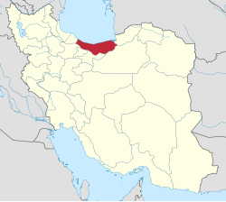
 Location of Mazandaran Province within Iran | |
| Coordinates: 36°23′N 52°11′E / 36.383°N 52.183°E[2] | |
| Country | Iran |
| Region | Region 1[1] |
| Capital | Babol |
| Counties | 22 |
| Government | |
| • Governor-general | Yousef Nouri |
| • MPs of Assembly of Experts | 1 Ali Moalemi 2 Norallah Tabresi 3 Sadeq Larijani 4 Seyed Rahim Tavakol 5 Seyed Sadegh Pishnamazi |
| • Representative of the Supreme Leader | Mohammad Bagher Mohammadi Laeeni |
| Area | |
| • Total | 23,833 km2 (9,202 sq mi) |
| Population (2016)[4] | |
| • Total | 3,283,582 |
| • Density | 140/km2 (360/sq mi) |
| Time zone | UTC+03:30 (IRST) |
| ISO 3166 code | IR-02 |
| Main language(s) | Mazandarani(Tabari)[5] |
| HDI (2017) | 0.845[6] very high · 4th |
Mazandaran Province (Persian: استان مازندران; )[a][b] is one of the 31 provinces of Iran. Its capital is the city of Sari.[7] Located along the southern coast of the Caspian Sea and in the adjacent Central Alborz mountain range, the province is in the central-northern part of the country. Mazandaran, founded in 1937, covers an area of 23,842 km2.[8][9]
At the time of the 2006 National Census, the province had a population of 2,893,087 in 783,169 households.[10] The following census in 2011 counted 3,073,943 people in 931,007 households.[11] At the most recent census in 2016, the population had risen to 3,283,582 in 1,084,798 households.[4] Mazandaran is one of the most densely populated provinces in Iran.[12]
The province has diverse natural resources, notably large reservoirs of oil and natural gas.[13] The diverse natural habitats of the province include plains, prairies, forests and rainforest[14] stretching from the sandy beaches of the Caspian Sea to the rugged and snowcapped Alborz sierra,[15] including Mount Damavand, one of the highest peaks and volcanoes in Asia.[16]
Mazandaran is a major producer of farmed fish,[17] and aquaculture provides an important economic addition to traditional dominance of agriculture.[18] Another important contributor to the economy is the tourism industry, as people from all of Iran enjoy visiting the area.[19] Mazandaran is also a fast-growing centre for biotechnology.[13]
- ^ "همشهری آنلاین-استانهای کشور به ۵ منطقه تقسیم شدند". 22 June 2014. Archived from the original on 23 June 2014. Retrieved 23 June 2014.
- ^ OpenStreetMap contributors (24 May 2024). "Fars Province" (Map). OpenStreetMap. Retrieved 24 May 2024.
- ^ "Province of Mazandaran". Iran Chamber Society. Archived from the original on 2 February 2017. Retrieved 11 September 2016.
- ^ a b "Census of the Islamic Republic of Iran, 1395 (2016)". AMAR (in Persian). The Statistical Center of Iran. p. 02. Archived from the original (Excel) on 7 October 2021. Retrieved 19 December 2022.
- ^ Maryam Borjian - Bilingualism in Mazandaran: Peaceful Coexistence With Persian. Archived September 21, 2006, at the Wayback Machine
- ^ "Sub-national HDI - Area Database - Global Data Lab". hdi.globaldatalab.org. Archived from the original on 23 September 2018. Retrieved 13 September 2018.
- ^ Habibi, Hassan (21 June 1369). "Approval of the organization and chain of citizenship of the elements and units of the divisions of Mazandaran province, centered in Sari city". Lamtakam (in Persian). Ministry of Interior, Defense Political Commission of the Government Council. Archived from the original on 14 January 2024. Retrieved 14 January 2024.
- ^ "Natural attractions of Mazandaran in IRIB". Archived from the original on 6 March 2017. Retrieved 27 November 2016.
- ^ http://www.sci.org.ir/content/userfiles/_sci_en/sci_en/sel/year85/f1/CS_01_4.HTM[permanent dead link]
- ^ "Census of the Islamic Republic of Iran, 1385 (2006)". AMAR (in Persian). The Statistical Center of Iran. p. 02. Archived from the original (Excel) on 20 September 2011. Retrieved 25 September 2022.
- ^ "Census of the Islamic Republic of Iran, 1390 (2011)". Syracuse University (in Persian). The Statistical Center of Iran. p. 02. Archived from the original (Excel) on 19 January 2023. Retrieved 19 December 2022.
- ^ Statistical Centre, Government of Iran. See: "General Characteristics of Ostans according to their administrative divisions at the end of 1383 (2005 CE)" [dead link], "Population estimation by urban and rural areas, 2005"[permanent dead link]
- ^ a b "University of Mazanderan". Archived from the original on 3 October 2008.
- ^ Springer Netherlands; July 10, 2005; Contributions to the knowledge of the useful plants and plant raw materials of Iran; ISSN 0921-9668
- ^ Mazandaran, Geography & History Archived February 28, 2008, at the Wayback Machine
- ^ "Elburz Mountains | mountain range, Iran". www.britannica.com. Archived from the original on 3 May 2008.
- ^ Freshwater Fishes of Iran Archived March 3, 2016, at the Wayback Machine; Revised: 12 July 2007
- ^ "Encyclopædia Britannica, Entry for Mazandaran". Archived from the original on 24 June 2007.
- ^ [1][permanent dead link] (Persian)
Cite error: There are <ref group=lower-alpha> tags or {{efn}} templates on this page, but the references will not show without a {{reflist|group=lower-alpha}} template or {{notelist}} template (see the help page).
© MMXXIII Rich X Search. We shall prevail. All rights reserved. Rich X Search


