Back مكنتوش Arabic مكنتوش ARZ مسینتوش، آلاباما AZB McIntosh (Alabama) Catalan Макинтош (Алабама) CE McIntosh (lungsod sa Tinipong Bansa, Alabama) CEB مەکینتۆش، ئەلاباما CKB McIntosh, Alabama Welsh McIntosh (Alabama) Spanish McIntosh (Alabama) Basque
McIntosh, Alabama | |
|---|---|
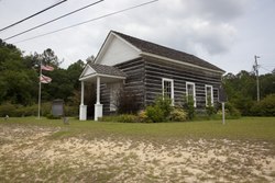 Andrews Chapel in McIntosh | |
 Location of McIntosh in Washington County, Alabama. | |
| Coordinates: 31°15′58″N 88°1′53″W / 31.26611°N 88.03139°W | |
| Country | United States |
| State | Alabama |
| County | Washington |
| Area | |
| • Total | 1.00 sq mi (2.58 km2) |
| • Land | 1.00 sq mi (2.58 km2) |
| • Water | 0.00 sq mi (0.00 km2) |
| Elevation | 49 ft (15 m) |
| Population (2020) | |
| • Total | 206 |
| • Density | 206.83/sq mi (79.85/km2) |
| Time zone | UTC-6 (Central Time (CT)) |
| • Summer (DST) | UTC-5 (CDT) |
| ZIP code | 36553 |
| Area code | 251 |
| FIPS code | 01-45472 |
| GNIS feature ID | 0152280 |
| Website | mcintoshal |
McIntosh, (originally known as McIntosh Bluff[2]), is a town located in Washington County, Alabama, United States along U.S. Route 43. It is 12+1⁄2 miles (20.1 km) south of Wagarville and 44 miles (71 km) north of Mobile. The population as of the 2020 U.S. Census was 206, down from 238 in 2010.
McIntosh is one of the most Native American towns in Alabama, with over half of the town's inhabitants reporting to be of Native descent in the 2020 census
The town and county have a high proportion of residents who are members of the MOWA Band of Choctaw Indians, a state-recognized tribe of people of the Muskogean-speaking language family. It has one site, Andrews Chapel, listed on the National Register of Historic Places.[3]
- ^ "2020 U.S. Gazetteer Files". United States Census Bureau. Retrieved October 29, 2021.
- ^ Kaetz, James P. "McIntosh". Encyclopedia of Alabama. Retrieved September 21, 2023.
- ^ "National Register Information System". National Register of Historic Places. National Park Service. March 13, 2009.
© MMXXIII Rich X Search. We shall prevail. All rights reserved. Rich X Search