Back ميلى شيويه شان ARZ Moirigkawagarbo CEB Montañas nevadas Mainri Spanish Monts Meili Xue French 梅里雪山 Japanese Moirigkawagarbo Swedish مېيلى قارلىق تېغى UG Núi tuyết Mai Lý Vietnamese 梅里雪山 Chinese
| Meili Snow Mountains | |
|---|---|
 | |
| Highest point | |
| Peak | Kawagebo |
| Elevation | 6,740 m (22,110 ft) |
| Coordinates | 28°26′14″N 98°41′04″E / 28.43722°N 98.68444°E |
| Dimensions | |
| Length | 200 km (120 mi) North-south |
| Width | 30 km (19 mi) East-west |
| Area | 6,000 km2 (2,300 sq mi) |
| Naming | |
| Native name |
|
| Geography | |
| Country | China |
| State | Yunnan |
| Rivers | Salween and Mekong |
| Settlement | Deqen is the closest settlement of considerable size |
| Parent range | Hengduan Mountain |
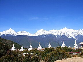
Meili Snow Mountains (Chinese: 梅里雪山; pinyin: Méilǐ Xuěshān), Mainri (སྨན་རི།) or Minling Snow Mountains (Tibetan: སྨིན་གླིང་གངས་རི།, Wylie: smin gling gangs ri[1]) is a mountain range in the Chinese province of Yunnan. It lies close to the northwestern boundary of the province and is bounded by the Nujiang river on the west and the Lancang River on the east. The Meili are subrange of the larger Nu Mountains, themselves a constituent range of the Hengduan group.
The crest of the range rises to over 6,000 metres (20,000 ft) above sea level, making for impressive prominence over the river valleys to the east and west, which are between 1,500 metres (4,900 ft) and 1,900 metres (6,200 ft) in elevation. The highest peak is Kawagarbo, which rises to 6,740 metres (22,110 ft). Kawagarbo is considered sacred for Tibetan Buddhists. Other significant peaks include Mianzimu, Cogar Laka and Jiariren-an. Because of restrictions and dangerous conditions, none of the major peaks in the range have ever been summited.
- ^ Chang jian Zang yu ren ming di ming ci dian = Dictionary of common Tibetan personal and place names. Guansheng Chen, Caidan An, 陈观胜., 安才旦. (Di 1 ban ed.). Beijing Shi: Wai wen chu ban she. 2004. ISBN 7-119-03497-9. OCLC 65173194.
{{cite book}}: CS1 maint: others (link)
© MMXXIII Rich X Search. We shall prevail. All rights reserved. Rich X Search
