Back Melinka Spanish ملینکا Persian Melinka French Melinka Italian Melinka Lithuanian Melinka Polish Melinka Romanian
Melinka
Isla Melinca | |
|---|---|
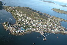
 Aerial view of Melinka | |
| Coordinates: 43°53′52″S 73°44′38″W / 43.89778°S 73.74389°W | |
| Region | Aisén |
| Province | Aisén |
| Commune | Guaitecas |
| Government | |
| • Alcalde | Luis Antonio Miranda Chiguay |
| Population (2017[1]) | |
| • Total | 1,329 |
| Sex | |
| • Men | 717 |
| • Women | 612 |
| Time zone | UTC−04:00 (Chilean Standard) |
| • Summer (DST) | UTC−03:00 (Chilean Daylight) |
| Climate | Cfb |
Melinka is a Chilean town in Aysén Province, Aysén Region. It is located on Ascención Island and is the administrative center of the commune of Guaitecas since 1979.
The town is on a small peninsula off the main island, and shelters a small harbor. The island is in the Guaitecas Archipelago, at the southern end of the Gulf of Corcovado.[2][3] Melinka is served by Melinka Airport and is connected by gravel road to the hamlets of Repollal.
Melinka is culturally similar to Chiloé Archipelago[4] but its inhabitants custom to bring dogs on board in their travels is likely rooted in native Chono traditions.[5][6]
In 2017 Melinka had a population of 1329 inhabitants down from 1411 in 2002.[1][7]
- ^ a b c "Ciudades, pueblos, aldeas y caceríos 2019" (PDF) (in Spanish). National Statistics Institute. 2019. Retrieved November 1, 2020.
- ^ Google Maps - Melinka
- ^ OpenStreetMap - Melinka
- ^ Saavedra Gallo, Gonzalo (2011). "Tensiones modernizantes y condicionantes culturales del desarrollo en el borde costero del Sur Austral chileno" [Modernizing tensions and cultural conditioners of development in the south austral Chilean coastal seaboard]. Revista Lider (in Spanish). 19: 201–219.
- ^ Álvarez A., Ricardo; Navarro P., Magdalena; Saavedra G., Gonzalo; Donoso C., Cristián (2015). "Referencias exploratorias sobre el lago Presidente Ríos, para sortear el Istmo de Ofqui, Península de Taitao, Región de Aysén" [Exploratory references on Presidente Ríos lake, for routes round the Ofqui Isthmus, Taitao Peninsula, Aysén Region, Chile]. Magallania (in Spanish). 43 (1). doi:10.4067/S0718-22442015000100006. Retrieved December 21, 2019.
- ^ Alvarez, R. & Navarro, M. (2008). Informes Levantamiento de Información Etnográfica Usos Tradicionales del Borde Costero Provincia de Chiloé (región de Los Lagos) y Comuna de Las Guaitecas (región de Aysén). Valdivia: ONG Centro Ballena Azul, World Wildlife Fund (WWF).
- ^ Chile: Ciudades, pueblos, aldeas y caseríos, Instituto nacional de estadísticas, June 2005, retrieved January 10, 2014
© MMXXIII Rich X Search. We shall prevail. All rights reserved. Rich X Search

