Back مقاطعة مرسر (أوهايو) Arabic مرسر بؤلگهسی، اوهایو AZB Mercer County, Ohio BAR Мърсър (окръг, Охайо) Bulgarian মারর্সের কাউন্টি, ওহাইও BPY Mercer Gông (Ohio) CDO Mercer County (kondado sa Tinipong Bansa, Ohio) CEB Mercer County (Ohio) Czech Mercer County, Ohio Welsh Mercer County (Ohio) Danish
Mercer County | |
|---|---|
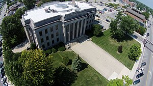
 Mercer County courthouse | |
 Location within the U.S. state of Ohio | |
 Ohio's location within the U.S. | |
| Coordinates: 40°32′N 84°38′W / 40.54°N 84.63°W | |
| Country | |
| State | |
| Founded | January 2, 1824 |
| Named for | Hugh Mercer |
| Seat | Celina |
| Largest city | Celina |
| Area | |
| • Total | 473 sq mi (1,230 km2) |
| • Land | 462 sq mi (1,200 km2) |
| • Water | 11 sq mi (30 km2) 2.3% |
| Population (2020) | |
| • Total | 42,528 |
| • Density | 90/sq mi (30/km2) |
| Time zone | UTC−5 (Eastern) |
| • Summer (DST) | UTC−4 (EDT) |
| Congressional district | 5th |
| Website | www |


Mercer County is located in the U.S. state of Ohio. As of the 2020 census, the population was 42,528.[1] Its county seat is Celina.[2] The county was created in 1820 and later organized in 1824.[3] It is named for Hugh Mercer, an officer in the American Revolutionary War.[4]
Mercer County comprises the Celina, Ohio Micropolitan Statistical Area
- ^ 2020 census
- ^ "Find a County". National Association of Counties. Archived from the original on May 31, 2011. Retrieved June 7, 2011.
- ^ "Ohio: Individual County Chronologies". Ohio Atlas of Historical County Boundaries. The Newberry Library. 2007. Archived from the original on April 6, 2016. Retrieved February 14, 2015.
- ^ "Mercer County data". Ohio State University Extension Data Center. Retrieved April 28, 2007.[dead link]
© MMXXIII Rich X Search. We shall prevail. All rights reserved. Rich X Search

