Back Merefo-Xerson körpüsü Azerbaijani Merefa-Cherson-Brücke German Merefa-ĥersona ponto Esperanto Puente Merefa-Jersón Spanish Merefan-H’ersonin silta Finnish Pont Merefa-Chersonèse French Ponte Merefa-Cherson Italian 메레파-헤르손 다리 Korean Мерефо-Херсонский железнодорожный мост Russian Мерефо-Херсонський міст Ukrainian
Merefa-Kherson bridge | |
|---|---|
 | |
| Coordinates | 48°28′03″N 35°04′58″E / 48.4674°N 35.0827°E |
| Carried | Merefa-Kherson railway line |
| Crossed | Dnieper river |
| Official name | Мерефо-Херсонський міст |
| Characteristics | |
| Material | Steel and reinforced concrete |
| Total length | 1,627 metres (5,338 ft) |
| Longest span | 2 × 10⁹ metres (358 ft) |
| History | |
| Construction start | 1912 |
| Construction end | 1932, 1951 |
| Opened | 1932, 21 December |
| Collapsed | 1914, 1940, 1944 (destroyed by troops) |
| Location | |
 | |

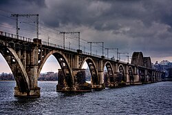
The Merefa-Kherson bridge (Ukrainian: Мерефо-Херсонський міст, Russian: Мерефо-Херсонский мост) is a 1,600 m (5,249.3 ft) single track railway bridge crossing the Dnieper in Dnipro and part of the railway line between cities of Merefa and Kherson.[1]
The second oldest bridge in the city, and the first railway-arch bridge in the Soviet Union, at the time of its construction it was the longest reinforced concrete arched bridge in Europe.[2]
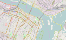
It crosses from the right bank of the Dnieper, over the "Bishop's Channel" ("Архієрейська протока") and Monastyrskyi Island, continuing over the main body of the river to its left bank.
- ^ Mykhailo Korniev; Wai-Fah Chen (volume editor/compiler); Lian Duan (volume editor/compiler) (2014). Bridge Engineering in Ukraine ... Arch and Frame Bridges. CRC Press. p. 881. ISBN 9781439810309.
{{cite book}}:|author2=has generic name (help);|work=ignored (help) - ^ "Merefa-Kherson bridge, Dnipropetrovsk". IGotoWorld. Retrieved 8 October 2015.
© MMXXIII Rich X Search. We shall prevail. All rights reserved. Rich X Search