Back جبل ميتاكوميت ريدج ARZ Metacomet Ridge CEB Metacomet Ridge German Metacomet Ridge French メタコメット山地 Japanese Метакомет-Ридж Russian
| Metacomet Ridge | |
|---|---|
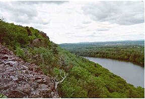
 Traprock cliffs on Chauncey Peak, Connecticut | |
| Highest point | |
| Peak | Mount Toby |
| Elevation | 1,269 ft (387 m) |
| Dimensions | |
| Length | 100 mi (160 km) north–south |
| Geography | |
| Country | United States |
| States | Connecticut and Massachusetts |
| Geology | |
| Formed by | Fault blocking |
| Age of rock | Triassic and Jurassic |
| Type of rock | Igneous and sedimentary |
The Metacomet Ridge, Metacomet Ridge Mountains, or Metacomet Range of southern New England is a narrow and steep fault-block mountain ridge known for its extensive cliff faces, scenic vistas, microclimate ecosystems, and rare or endangered plants. The ridge is an important recreation resource located within 10 miles (16 km) of more than 1.5 million people, offering four long-distance hiking trails and over a dozen parks and recreation areas, including several historic sites. It has been the focus of ongoing conservation efforts because of its natural, historic, and recreational value, involving municipal, state, and national agencies and nearly two dozen non-profit organizations.[1][2]
The Metacomet Ridge extends from Branford, Connecticut, on Long Island Sound, through the Connecticut River Valley region of Massachusetts, to northern Franklin County, Massachusetts, 2 miles (3 km) short of the Vermont and New Hampshire borders for a distance of 100 miles (160 km). It is geologically distinct from the nearby Appalachian Mountains and surrounding uplands, and is composed of volcanic basalt (also known as trap rock) and sedimentary rock in faulted and tilted layers many hundreds of feet thick. In most cases, the basalt layers are dominant, prevalent, and exposed. The ridge rises dramatically from much lower valley elevations, although only 1,200 feet (370 m) above sea level at its highest, with an average summit elevation of 725 feet (221 m).[1][3]
- ^ a b "Metacomet-Mattabesett Trail Natural Resource Assessment" (PDF). Farnsworth, Elizabeth J. (2004). Archived from the original (PDF) on 7 August 2007. Retrieved June 14, 2015.
- ^ United States Census Bureau. Data retrieved December 20, 2007.
- ^ DeLorme Topo 6.0 (2006). Mapping software. Yarmouth, Maine: DeLorme.
© MMXXIII Rich X Search. We shall prevail. All rights reserved. Rich X Search