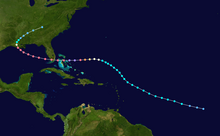
 The path of Hurricane Andrew | |
| Meteorological history | |
|---|---|
| Formed | August 16, 1992 |
| Extratropical | August 28 |
| Dissipated | August 29, 1992 |
| Category 5 major hurricane | |
| 1-minute sustained (SSHWS/NWS) | |
| Highest winds | 175 mph (280 km/h) |
| Lowest pressure | 922 mbar (hPa); 27.23 inHg |
| Overall effects | |
| Areas affected | Bahamas, Southern United States, Mid-Atlantic states |
Part of the 1992 Atlantic hurricane season | |
| General
Effects Other wikis | |
The meteorological history of Hurricane Andrew, the strongest tropical cyclone of the 1992 Atlantic hurricane season, lasted from mid to late August 1992. The hurricane developed from a tropical wave that moved off the coast of Africa on August 14. Tracking westward due to a ridge, favorable conditions allowed it to develop into Tropical Depression Three on August 16 in the deep tropical Atlantic Ocean. The cyclone gradually intensified, becoming a tropical storm on August 17. However, wind shear soon impacted the storm, causing significant increases in barometric pressure and nearly destroying its low-level circulation by August 20. Wind shear sharply decreased starting on August 21, and with warm sea surface temperatures, Andrew began rapid deepening, starting on the following day. By August 23, Andrew peaked as a Category 5 hurricane on the Saffir–Simpson hurricane wind scale while approaching The Bahamas.
The cyclone weakened slightly before making landfall on Eleuthera later that day and the Berry Islands early on August 24. However, the storm then rapidly, but briefly restrengthened into a Category 5 hurricane, and was at that intensity when it struck Elliott Key and just south of Homestead, Florida on August 24. Andrew weakened while crossing Florida, but only reduced to a Category 4 hurricane while it emerged into the Gulf of Mexico. The storm re-intensified slightly in the Gulf, causing it to maintain its status as a Category 4 hurricane. Early on August 26, Andrew weakened slightly to a low-end Category 3 hurricane before making landfall near Morgan City, Louisiana. Once inland, the cyclone rapidly weakened, and less than 24 hours after landfall, Andrew was merely a tropical depression. It continued northeastward across the Southern United States, becoming extratropical on August 28, before merging with a frontal system on August 29, while centered over the southern Appalachian Mountains.
© MMXXIII Rich X Search. We shall prevail. All rights reserved. Rich X Search
