Back Maas Afrikaans Mǣs ANG نهر الميز Arabic نهر الميز ARZ Maas Azerbaijani موز چایی AZB Маас (рака) Byelorussian Маас BE-X-OLD Маас Bulgarian মোজ নদী Bengali/Bangla
| Meuse | |
|---|---|
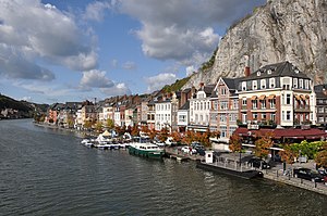
 The Meuse at Dinant | |
 Basin of the Meuse | |
| Native name |
|
| Location | |
| Countries | |
| Region | Western Europe |
| Cities |
|
| Physical characteristics | |
| Source | |
| • location | Pouilly-en-Bassigny, Le Châtelet-sur-Meuse, Haute-Marne, Grand Est, France |
| • coordinates | 47°59′12″N 5°37′00″E / 47.9867°N 5.6167°E |
| • elevation | 409 m (1,342 ft) |
| Mouth | North Sea |
• location | Hollands Diep, North Brabant/South Holland, Netherlands |
• coordinates | 51°42′54″N 4°40′04″E / 51.715°N 4.6678°E |
• elevation | 0 m (0 ft) |
| Length | 925 km (575 mi) |
| Basin size | 34,548 km2 (13,339 sq mi) |
| Discharge | |
| • average | 350 m3/s (12,000 cu ft/s) |
[1] | |
The Meuse[a] or Maas[b] is a major European river, rising in France and flowing through Belgium and the Netherlands before draining into the North Sea from the Rhine–Meuse–Scheldt delta. It has a total length of 925 km (575 miles).
- ^ Marcel de Wit, Robert Leander, Adri Buishand: Extreme discharges in the Meuse basin Archived 2014-01-06 at the Wayback Machine, p. 2
(The frequently mentioned figure of 250 m3/s refers to the Borgharen gauge near the frontier between Belgium and the Netherlands representing two thirds of the basin.) - ^ a b "Meuse". The American Heritage Dictionary of the English Language (5th ed.). HarperCollins. Retrieved April 4, 2019.
- ^ "Meuse" (US) and "Meuse". Lexico UK English Dictionary. Oxford University Press. Archived from the original on 2020-02-09.
- ^ a b "Meuse". Merriam-Webster.com Dictionary. Merriam-Webster. Retrieved April 4, 2019.
- ^ "Maas". Lexico US English Dictionary. Oxford University Press. Archived from the original on 2020-02-26.
Cite error: There are <ref group=lower-alpha> tags or {{efn}} templates on this page, but the references will not show without a {{reflist|group=lower-alpha}} template or {{notelist}} template (see the help page).
© MMXXIII Rich X Search. We shall prevail. All rights reserved. Rich X Search