| Canadian Middle Arctic Tundra | |
|---|---|
 | |
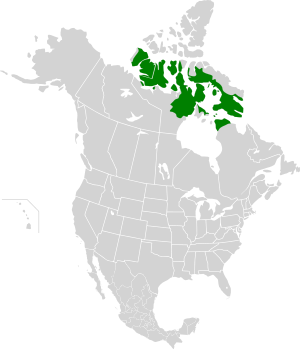
 Ecoregion territory (in green) | |
| Ecology | |
| Realm | Nearctic |
| Biome | Tundra |
| Borders | |
| Geography | |
| Area | 1,034,340 km2 (399,360 sq mi) |
| Country | Canada |
| Province/Territory | |
| Coordinates | 67°15′N 91°45′W / 67.25°N 91.75°W |
| Climate type | Polar |
The Canadian Middle Arctic Tundra ecoregion covers a broad stretch of northern Canada - the southern islands of the Arctic Archipelago, plus the northern mainland of Nunavut and, across Hudson Bay to the east, a portion of northern Quebec.[1][2][3][4][5] This is the coldest and driest ecoregion in Canada, and can be referred to as a 'polar desert'. It is an important region for breeding and migratory birds, and supports 80% of the world's muskox.[1]
- ^ a b "Middle Arctic tundra". World Wildlife Federation. Retrieved March 21, 2020.
- ^ "Map of Ecoregions 2017". Resolve, using WWF data. Retrieved September 14, 2019.
- ^ "Middle Arctic tundra". Digital Observatory for Protected Areas. Retrieved August 1, 2020.
- ^ "Middle Arctic tundra". The Encyclopedia of Earth. Retrieved August 28, 2020.
- ^ https://www.oneearth.org/ecoregions/canadian-middle-arctic-tundra/
© MMXXIII Rich X Search. We shall prevail. All rights reserved. Rich X Search
