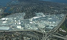
The Midway area, also referred to as the North Bay area, is a neighborhood of San Diego, California. It is located at the northern (mainland) end of the Point Loma peninsula, northwest of downtown San Diego and just west of Old Town. It is often considered to be part of Point Loma, although the city treats it as a separate Planning Area.
The boundaries of the Midway community plan are the San Diego River and Interstate 8 to the north, Interstate 5 to the east, Laurel Street to the south, and Lytton Street and the bluffs above Kenyon Street to the west.[1] In addition to the core Midway area, the community plan includes portions of the historic neighborhoods of Five Points and Middletown. The planning area encompasses approximately 800 acres (320 ha) of mostly flatland. The area is primarily commercial and industrial, plus a few small pockets of multi-family residential development.[1]
© MMXXIII Rich X Search. We shall prevail. All rights reserved. Rich X Search
