Back میلرز پوینت، نیو ساوت ولز Persian מילרס פוינט HE Millers Point, New South Wales Malay Millers Point, New South Wales Romanian ملرز پوائنٹ، نیو ساؤتھ ویلز Urdu 美羅仕般 (新南威爾斯州) Chinese
| Millers Point Sydney, New South Wales | |||||||||||||||
|---|---|---|---|---|---|---|---|---|---|---|---|---|---|---|---|
 | |||||||||||||||
 | |||||||||||||||
| Population | 1,735 (SAL 2021)[1] | ||||||||||||||
| Postcode(s) | 2000 | ||||||||||||||
| Area | 0.5 km2 (0.2 sq mi) | ||||||||||||||
| Location | 1 km (1 mi) north-west of Sydney CBD | ||||||||||||||
| LGA(s) | City of Sydney | ||||||||||||||
| Parish | St. Philip | ||||||||||||||
| State electorate(s) | Sydney | ||||||||||||||
| Federal division(s) | Sydney | ||||||||||||||
| |||||||||||||||
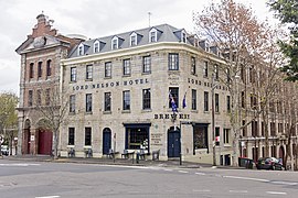
Millers Point is an inner-city suburb of Sydney, in the state of New South Wales, Australia. It is on the north-western edge of the Sydney central business district, adjacent to The Rocks and is part of the local government area of the City of Sydney.
Millers Point lies on the southern shore of Sydney Harbour, beside Darling Harbour. The Barangaroo development is taking place on 22 hectares of land on the western side of the suburb.[2] Sections of Millers Point have been included as part of The Rocks area in the past and some residents and businesses still use it in their address.[citation needed]
- ^ Australian Bureau of Statistics (28 June 2022). "Millers Point (suburb and locality)". Australian Census 2021 QuickStats. Retrieved 28 June 2022.
- ^ Barangaroo a north shore girl Archived 7 February 2012 at the Wayback Machine, City of Sydney, 19 October 2006. Retrieved 5 December 2006.
© MMXXIII Rich X Search. We shall prevail. All rights reserved. Rich X Search