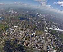


The Milton Keynes urban area or Milton Keynes Built-up Area is a designation established by the United Kingdom's Office for National Statistics.[1][a] Milton Keynes has no statutory boundary: the 1967 designated area only determined the area assigned to the Milton Keynes Development Corporation for development. The wider urban area outside that designation includes Newport Pagnell and Woburn Sands as well as Aspley Guise (Bedfordshire) and part of Stoke Hammond civil parish.[1]
At the 2021 census, the population of Milton Keynes's Built-up Area was 264,349,[2] an increase of 11.5% over the figure of 229,941 recorded at the 2011 census.[1] That in turn was an increase of almost 25% on the population recorded in the 2001 census of 184,506.[3]
- ^ a b c UK Census (2011). "Local Area Report – Milton Keynes Built-up area (E34005056)". Nomis. Office for National Statistics. Retrieved 29 March 2019.
- ^ "UNITED KINGDOM: Countries and Major Urban Areas". citypopulation.de. 11 November 2022. Retrieved 23 November 2022.
- ^ "Census 2001 Key Statistics, Urban areas in England and Wales" (PDF). ONS. Retrieved 3 July 2013.
Cite error: There are <ref group=lower-alpha> tags or {{efn}} templates on this page, but the references will not show without a {{reflist|group=lower-alpha}} template or {{notelist}} template (see the help page).
© MMXXIII Rich X Search. We shall prevail. All rights reserved. Rich X Search
