Back 3.º distrito congresional de Minnesota Spanish حوزه انتخابیه سوم مینهسوتا Persian Troisième district congressionnel du Minnesota French Minnesota's 3rd congressional district SIMPLE 明尼蘇達州第三國會選區 Chinese
| Minnesota's 3rd congressional district | |||
|---|---|---|---|
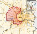
Interactive map of district boundaries since January 3, 2023, with Hennepin County highlighted in red | |||
| Representative |
| ||
| Area | 468[1] sq mi (1,210 km2) | ||
| Distribution |
| ||
| Population (2022) | 700,754[3] | ||
| Median household income | $100,867[4] | ||
| Ethnicity |
| ||
| Cook PVI | D+8[5] | ||
| External image | |
|---|---|
Minnesota's 3rd congressional district encompasses the suburbs of Hennepin and Anoka counties to the west, south, and north of Minneapolis. The district, which is mostly suburban in character, includes a few farming communities on its far western edge and also inner-ring suburban areas on its eastern edge. The district includes the blue collar cities of Brooklyn Park and Coon Rapids to the north-east, middle-income Bloomington to the south, and higher-income Eden Prairie, Edina, Maple Grove, Plymouth, Minnetonka, and Wayzata to the west. Democrat Dean Phillips currently represents the district in the U.S. House of Representatives, after defeating incumbent Republican Erik Paulsen in the 2018 midterm elections.
The 3rd congressional district has the highest median household income out of Minnesota's congressional districts, with a median household income of $100,867, compared to the state average of $74,593. 12 percent of residents of the 3rd congressional district are immigrants; the largest countries of origin being India, Mexico, Laos, Liberia, and Vietnam. The largest immigrant populations in the district are concentrated in Brooklyn Park, one of the most culturally diverse cities in Minnesota, as well as in Eden Prairie and Bloomington.[6]
- ^ "Minnesota congressional districts by urban and rural population and land area" (PDF). US Census Bureau. 2000. Retrieved April 2, 2007.
- ^ "Congressional Districts Relationship Files (state-based)". www.census.gov. US Census Bureau Geography. Retrieved April 7, 2018.
- ^ "My Congressional District". www.census.gov. Center for New Media & Promotion (CNMP), US Census Bureau. Retrieved October 5, 2023.
- ^ "My Congressional District".
- ^ "2022 Cook PVI: District Map and List". Cook Political Report. Retrieved January 10, 2023.
- ^ "The Demographic Statistical Atlas of the United States - Statistical Atlas". statisticalatlas.com. Retrieved March 14, 2024.
© MMXXIII Rich X Search. We shall prevail. All rights reserved. Rich X Search

