| Mississippi River System | |
|---|---|
 Mississippi River course, watershed, and major tributaries | |
 Details of the Mississippi River tributaries | |
| Location | |
| Country | United States and Canada |
| Physical characteristics | |
| Mouth | |
• location | Gulf of Mexico |
• coordinates | 29°09′04″N 89°15′12″W / 29.15111°N 89.25333°W |
• elevation | 0 ft (0 m) |
| Basin size | 1,151,000 km2 (444,000 sq mi) |
| Discharge | |
| • location | mouth; max and min at Baton Rouge, LA[1] |
| • average | 593,000 cu ft/s (16,800 m3/s)[1] |
| • minimum | 159,000 cu ft/s (4,500 m3/s) |
| • maximum | 3,065,000 cu ft/s (86,800 m3/s) |
| Discharge | |
| • location | St. Louis[2] |
| • average | 168,000 cu ft/s (4,800 m3/s)[2] |
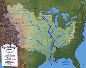
The Mississippi River System, also referred to as the Western Rivers, is a mostly riverine network of the United States which includes the Mississippi River and connecting waterways. The Mississippi River is the largest drainage basin in the United States.[3] In the United States, the Mississippi drains about 59% of the country's rivers.[4]
From the perspective of natural geography and hydrology, the system consists of the Mississippi River itself and its numerous natural tributaries and distributaries. The major tributaries are the Illinois, Missouri, Ohio and Red rivers. Given their flow volumes, major Ohio River tributaries like the Allegheny, Tennessee, and Wabash rivers are considered important tributaries to the Mississippi system.[5] Before the Mississippi River reaches the Gulf of Mexico, it runs into its distributary, the Atchafalaya River.[3]
From the perspective of modern commercial navigation, the system includes the above as well as navigable inland waterways which are connected by artificial means. Important connecting waterways include the Illinois Waterway, the Tennessee-Tombigbee Waterway, and the Gulf Intracoastal Waterway. is maintained by the U.S. Army Corps of Engineers with a project depth of between 9–12 ft (2.7–3.7 m) to accommodate barge transportation, primarily of bulk commodities.[6]
The Mississippi River carries 60% of U.S. grain shipments, 22% of oil and gas shipments, and 20% of coal.[7]
- ^ a b Kammerer, J.C. (May 1990). "Largest Rivers in the United States". U.S. Geological Survey. Archived from the original on June 30, 2017. Retrieved February 22, 2011.
- ^ a b Median of the 14,610 daily streamflows recorded by the USGS for the period 1967–2006.
- ^ a b "The Mississippi/Atchafalaya River Basin (MARB)". www.epa.gov. US Environmental Protection Agency. 24 March 2015. Retrieved 2 November 2016.
- ^ Cite error: The named reference
Watkinswas invoked but never defined (see the help page). - ^ "Mississippi River". USGS Biological Resources. Archived from the original on 2005-10-28. Retrieved 2006-03-08.
- ^ "The Mississippi River System". US Army Corps of Engineers. Archived from the original on 2006-04-09. Retrieved 2006-03-08.
- ^ Alan Greenblatt (2013-01-10). "Mississippi Blues: When The River Doesn't Run". NPR. Retrieved 2015-11-26.
© MMXXIII Rich X Search. We shall prevail. All rights reserved. Rich X Search
