Back Moana (bahin nga lungsod) CEB ماوانا، استرالیای جنوبی Persian Moana (del av en befolkad plats) Swedish
| Moana Adelaide, South Australia | |||||||||||||||
|---|---|---|---|---|---|---|---|---|---|---|---|---|---|---|---|
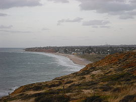
 A view of Moana from the south | |||||||||||||||
| Coordinates | 35°11′53″S 138°28′23″E / 35.198°S 138.473°E | ||||||||||||||
| Population | 3,316 (SAL 2021)[1] | ||||||||||||||
| Postcode(s) | 5169 | ||||||||||||||
| LGA(s) | City of Onkaparinga | ||||||||||||||
| Region | Southern Adelaide[2] | ||||||||||||||
| County | Adelaide[3] | ||||||||||||||
| |||||||||||||||
| Footnotes | Adjoining suburbs[4] | ||||||||||||||
Moana is an outer coastal suburb in the south of Adelaide, South Australia. The suburb is approximately 36.4 km from the Adelaide city centre. It lies within the City of Onkaparinga local government area, and neighbours the suburbs Seaford, Maslin Beach, Seaford Rise and Port Noarlunga[4] It is divided into two by Pedler Creek and the associated sand dune reserve. The beach is often referred to as Moana Beach.
Ochre Point lies between Moana and Maslin Beach.[5] Ochre Cove, or Red Ochre Cove, lies just south of the point.[6] There is a large deposit of red ochre near the cove, which was used as a source by the traditional owners, the Kaurna people.[7] The cove was known as Potartang,[8] also spelt Putatang, or Mulgali (the latter the Ngarrindjeri word for ochre),[9] is a site of significance and part of the Tjilbruke Dreaming Trail.[8]
- ^ Australian Bureau of Statistics (28 June 2022). "Moana (suburb and locality)". Australian Census 2021 QuickStats. Retrieved 28 June 2022.
- ^ "Southern Adelaide SA Government region" (PDF). The Government of South Australia. Retrieved 17 April 2017.
- ^ "Search result for "County of Adelaide, CNTY" with the following data sets selected – "Counties" and "Local Government Areas"". Property Location SA Map Viewer. Government of South Australia. Retrieved 24 April 2017.
- ^ a b "City of Onkaparinga suburb boundaries map". City of Onkaparinga. 9 January 2014. Archived from the original on 24 September 2015. Retrieved 8 October 2014.
- ^ "Ochre Point – Beach in Maslin Beach Onkaparinga SA". SLS Beachsafe. Retrieved 16 November 2020.
- ^ "Ochre Point". Google Maps. Retrieved 16 November 2020.
- ^ Popelka-Filcoff, R. S.; Lenehan, C. E.; Lombi, E.; Donner, E.; Howard, D. L.; Jonge, M. D. de; Paterson, D.; Walshe, K.; Pring, A. (22 February 1999). "Microelemental characterisation of Aboriginal Australian natural Fe oxide pigments". Analytical Methods. 7 (17): 7363–7380. doi:10.1039/C5AY01547B. hdl:2440/96867.
- ^ a b "Tjilbruke Dreaming Tracks". Kaurnaculture. 16 October 2013. Retrieved 16 November 2020.
- ^ "Place Name Summary (PNS) 4.03.02/05: Mulgali" (PDF). Kaurna YarraPintyandi: The Southern Kaurna Place Names Project. University of Adelaide.
© MMXXIII Rich X Search. We shall prevail. All rights reserved. Rich X Search
