Back مقاطعة موبيل (ألاباما) Arabic موبیل بؤلگهسی، آلاباما AZB Mobile County, Alabama BAR Мобил (окръг, Алабама) Bulgarian মোবাইল কাউন্টি, আলাবামা BPY Comtat de Mobile Catalan Mobile Gông (Alabama) CDO Мобил (гуо, Алабама) CE Mobile County CEB شارستانی مۆبیل، ئەلاباما CKB
30°47′11″N 88°12′50″W / 30.78639°N 88.21389°W
Mobile County | |
|---|---|
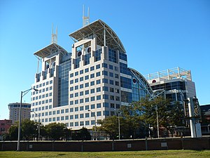
 Mobile Government Plaza in Mobile | |
 Location within the U.S. state of Alabama | |
 Alabama's location within the U.S. | |
| Coordinates: 30°47′11″N 88°12′50″W / 30.7864°N 88.2139°W | |
| Country | |
| State | |
| Founded | December 18, 1812[1] |
| Named for | Mobile Bay |
| Seat | Mobile |
| Largest city | Mobile |
| Area | |
| • Total | 1,644 sq mi (4,260 km2) |
| • Land | 1,229 sq mi (3,180 km2) |
| • Water | 415 sq mi (1,070 km2) 25.2% |
| Population (2020) | |
| • Total | 414,809 |
| • Estimate (2023) | 411,640 |
| • Density | 250/sq mi (97/km2) |
| Time zone | UTC−6 (Central) |
| • Summer (DST) | UTC−5 (CDT) |
| Congressional district | 1st |
| Website | mobilecountyal |
| |
Mobile County (/moʊˈbiːl/ moh-BEEL) is located in the southwestern corner of the U.S. state of Alabama. It is the third-most populous county in the state after Jefferson and Madison counties. As of the 2020 census, its population was 414,809.[2] Its county seat is Mobile, which was founded as a deepwater port on the Mobile River. The only such port in Alabama, it has long been integral to the economy for providing access to inland waterways as well as the Gulf of Mexico.[3]
The city, river, and county were named in honor of Maubila, a village of the paramount chief Tuskaloosa of the regional Mississippian culture. In 1540 he arranged an ambush of soldiers of Hernando de Soto's expedition in an effort to expel them from the territory. The Spaniards were armed with guns and killed many of the tribe. Mobile County and Washington County, Alabama make up the Mobile Metropolitan Statistical Area with a 2020 population of 430,197. The Mobile, AL MSA and Daphne-Fairhope-Foley, AL MSA make up the much larger Mobile-Daphne-Fairhope CSA with a 2020 population of 661,964.
The northern border of Mobile County and southern area of neighboring Washington County constitute the homeland of the state-recognized tribe of MOWA Band of Choctaw Indians, descendants of Choctaw and Creek who stayed in this area during the period of Indian Removal. They have organized to preserve their culture and language. They were the first of nine tribes to be recognized by the state.
- ^ Cite error: The named reference
ArcALwas invoked but never defined (see the help page). - ^ "State & County QuickFacts". United States Census Bureau. Retrieved March 14, 2024.
- ^ "Find a County". National Association of Counties. Retrieved June 7, 2011.
© MMXXIII Rich X Search. We shall prevail. All rights reserved. Rich X Search

