Back ሞሃቬ ካውንቲ፥ አሪዞና Amharic مقاطعة موهاف (أريزونا) Arabic Mohave County, Arizona BAR Мохаве (окръг) Bulgarian মোহাবে কাউন্টি, অ্যারিজোনা BPY Comtat de Mohave Catalan Mohave Gông (Arizona) CDO Мохаве (гуо, Аризона) CE Mohave County CEB Mohave County Czech
Mohave County | |
|---|---|
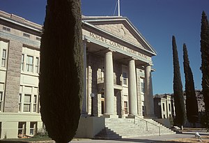
 Mohave County Courthouse in Kingman | |
 Location within the U.S. state of Arizona | |
 Arizona's location within the U.S. | |
| Coordinates: 35°40′55″N 113°51′47″W / 35.6819°N 113.8631°W | |
| Country | |
| State | |
| Founded | November 9, 1864 |
| Named for | Fort Mohave |
| Seat | Kingman |
| Largest city | Lake Havasu City |
| Area | |
| • Total | 13,461 sq mi (34,860 km2) |
| • Land | 13,311 sq mi (34,480 km2) |
| • Water | 150 sq mi (400 km2) 1.1% |
| Population (2020) | |
| • Total | 213,267 |
| • Estimate (2023) | 223,682 |
| • Density | 16/sq mi (6.1/km2) |
| Time zone | UTC−7 (Mountain) |
| Congressional districts | 2nd, 9th |
| Website | www |
Mohave County is in the northwestern corner of the U.S. state of Arizona. As of the 2020 census, its population was 213,267.[1] The county seat is Kingman,[2] and the largest city is Lake Havasu City. It is the fifth largest county in the United States (by area).
Mohave County includes the Lake Havasu City–Kingman, Arizona Metropolitan Statistical Area, which is also included in the Las Vegas-Henderson, Nevada-Arizona Combined Statistical Area.
Mohave County contains parts of Grand Canyon National Park and Lake Mead National Recreation Area and all of the Grand Canyon–Parashant National Monument. The Kaibab, Fort Mojave and Hualapai Indian Reservations also lie within the county.
- ^ "State & County QuickFacts". United States Census Bureau. Retrieved September 27, 2022.
- ^ "Find a County". National Association of Counties. Retrieved June 7, 2011.
© MMXXIII Rich X Search. We shall prevail. All rights reserved. Rich X Search
