Back نهر مولونغلو Arabic نهر مولونجلو ARZ Molonglo River CEB Molonglo River German Río Molonglo Spanish Molonglo jõgi Estonian رود مولونگلو Persian Molonglo French Molonglo-folyó Hungarian 몰롱글로강 Korean
| Molonglo | |
|---|---|
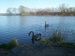
 Black swans on Molonglo River | |
| Etymology | Aboriginal: "like the sound of thunder"[1] |
| Native name | Yeal-am-bid-gie[2] |
| Location | |
| Country | Australia |
| State/Territory | |
| Regions | |
| Districts | |
| City | Queanbeyan |
| Physical characteristics | |
| Source | Tinderry Range, Great Dividing Range |
| • location | near Captains Flat |
| • coordinates | 35°40′5″S 149°29′50″E / 35.66806°S 149.49722°E |
| • elevation | 1,130 m (3,710 ft) |
| Mouth | confluence with the Murrumbidgee River |
• location | near Uriarra Crossing |
• coordinates | 35°14′30″S 148°58′4″E / 35.24167°S 148.96778°E |
• elevation | 440 m (1,440 ft) |
| Length | 115 km (71 mi) |
| Basin size | 198,900 km2 (76,800 sq mi) |
| Basin features | |
| River system | Murrumbidgee River, Murray–Darling basin |
| Tributaries | |
| • left | Queanbeyan River, Jerrabomberra Creek |
| • right | Sullivans Creek |
| Nature reserves | Molonglo Gorge Recreation Reserve, Jerrabomberra Wetlands, Lower Molonglo Nature Reserve |
| [3] | |
The Molonglo River is a perennial river[4] that is part of the Murrumbidgee catchment within the Murray–Darling basin. It is located in the Monaro and Capital Country regions of New South Wales and the Australian Capital Territory, in Australia.
- ^ Cite error: The named reference
actecwas invoked but never defined (see the help page). - ^ Cite error: The named reference
abswas invoked but never defined (see the help page). - ^ "Map of Molonglo River". Bonzle Digital Atlas of Australia. Retrieved 21 January 2013.
- ^ "Molonglo River". Geographical Names Register (GNR) of NSW. Geographical Names Board of New South Wales. Retrieved 21 January 2013.
© MMXXIII Rich X Search. We shall prevail. All rights reserved. Rich X Search
