Back جبل مونت ايجوال ARZ Augal Breton Mont Augal Catalan Mont Aigoual CEB Mont Aigoual German Aigoual mendia Basque Mont Aigoual French Monte Aigoual Italian Mont Aigoual LLD Mont Aigoual Dutch
| Mont Aigoual | |
|---|---|
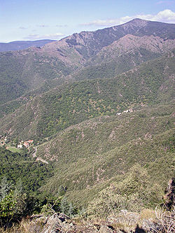
 East face of Mont Aigoual | |
| Highest point | |
| Elevation | 1,567 m (5,141 ft) |
| Prominence | 730 m (2,400 ft) |
| Coordinates | 44°07′22″N 3°34′30″E / 44.12278°N 3.57500°E |
| Geography | |
| Location | |
| Parent range | Massif Central |

Mont Aigoual (French pronunciation: [mɔ̃ ɛɡwal]; Occitan: Mont Augal, elevation 1567m / 5141 ft) is the highest point of the Gard department, France. It is part of the Massif Central, and it is located within the Cévennes National Park. Its southern slopes are the source of the river Hérault flowing into the Mediterranean.
When the sky is clear, it is possible to see the Mediterranean Sea, the Pyrenees, and also the Alps and Mont Blanc in particular. The summit is accessible by car from a variety of converging surfaced approaches.
© MMXXIII Rich X Search. We shall prevail. All rights reserved. Rich X Search