Back Moora (lungsod sa Ostralya, State of Western Australia, Moora) CEB Moora (Western Australia) German مورا، استرالیای غربی Persian Moora French Moora Italian Moora Dutch Moora (Australia) Polish Moora, Western Australia Swedish مورا، مغربی آسٹریلیا Urdu
| Moora Western Australia | |||||||||
|---|---|---|---|---|---|---|---|---|---|
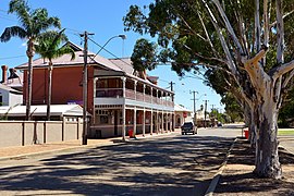
 Moora, Western Australia. | |||||||||
 | |||||||||
| Population | 1,591 (UCL 2021)[1] | ||||||||
| Established | 1895 | ||||||||
| Postcode(s) | 6510 | ||||||||
| Elevation | 203 m (666 ft) | ||||||||
| Area | 361 km2 (139 sq mi) | ||||||||
| Location |
| ||||||||
| LGA(s) | Shire of Moora | ||||||||
| State electorate(s) | Moore | ||||||||
| Federal division(s) | Durack | ||||||||
| |||||||||
30°38′17″S 116°00′36″E / 30.638°S 116.01°E
Moora is a townsite located 177 km north of Perth in the Wheatbelt region of Western Australia. At the 2021 census, Moora had a population of 1,755.
- ^ Australian Bureau of Statistics (28 June 2022). "Moora (urban centre and locality)". Australian Census 2021.
© MMXXIII Rich X Search. We shall prevail. All rights reserved. Rich X Search