Back سد موسى سوندرز باور ARZ Moses-Saunders Dam CEB R. H. Saunders vannkraftverk NB ГЕС Мозес-Сондерс Ukrainian
| Moses-Saunders Power Dam | |
|---|---|
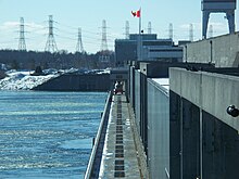
 The dam's R.H. Saunders Generating Station | |
| Official name | Robert Moses-Robert H. Saunders Power Dam |
| Country | United States/Canada |
| Location | Massena, New York Cornwall, Ontario |
| Coordinates | 45°00′23″N 74°47′42″W / 45.00639°N 74.79500°W |
| Status | Operational |
| Construction began | 1954 |
| Opening date | 1958 |
| Owner(s) | New York Power Authority Ontario Power Generation |
| Dam and spillways | |
| Impounds | Saint Lawrence River |
| Height | 195.5 ft (60 m)[1] |
| Length | 3,216 ft (980 m) |
| Spillways | Long Sault Dam |
| Reservoir | |
| Creates | Lake St. Lawrence |
| Surface area | 100 sq mi (259 km2)[2] |
| Maximum length | 30 mi (48 km) |
| Power Station | |
| Commission date | R.H. Saunders: July 8, 1958-December 18, 1959[3] |
| Hydraulic head | 81 ft (25 m)[4] |
| Turbines | R.H. Saunders: 16 x 65.3 MW fixed-pitch Kaplan-type St. Lawrence/FDR: 16 x 57 MW fixed pitch Kaplan-type[5] |
| Installed capacity | R.H. Saunders: 1,045 MW St. Lawrence/FDR: 912 MW Total: 1,957 MW |
The Moses-Saunders Power Dam, short for Robert Moses-Robert H. Saunders Power Dam, is a dam on the Saint Lawrence River straddling the border between the United States and Canada. It is located between Massena in New York and Cornwall in Ontario. The dam supplies water to two adjacent hydroelectric power generating stations, the United States' 912 MW St. Lawrence-Franklin D. Roosevelt Power Project and Canada's 1,045 MW R.H. Saunders Generating Station. Constructed between 1954 and 1958 as part of the larger Saint Lawrence Seaway project, the dam created Lake St. Lawrence. Aside from providing significant amounts of renewable power, the dam regulates the St. Lawrence River and affords passage for the navigation of large vessels. Despite the enormous economic advantages to the dam, it required the relocation of 6,500 people and caused harm to the surrounding environment. Efforts have been made over the years to improve shoreline and fish habitats.
The dam regulates the level of Lake Ontario.[6]
- ^ Parham, Claire Puccia (2009). The St. Lawrence Seaway and Power Project : an oral history of the greatest construction show on earth (1st ed.). Syracuse, N.Y.: Syracuse University Press. pp. xxiii. ISBN 978-0-8156-0913-1.
- ^ "St. Lawrence River (International Section)". U.S. Army Corps of Engineers. Retrieved 5 March 2012.
- ^ "R.H. Saunders Station". Ontario Power Generation Inc. Archived from the original on 5 February 2012. Retrieved 5 March 2012.
- ^ "Order Approving Settlement Agreements, Dismissing Complaint and Issuing New License" (PDF). Federal Energy Regulatory Commission. 23 October 2003. Retrieved 5 March 2012.
- ^ "The HydroX System" (PDF). Orbit. 2004. Retrieved 5 March 2012.
- ^ Armstrong, Leslie (August 14, 2014). "Great Lakes Water Levels Rebound Thanks to Prolonged Winter". Toronto Star.
© MMXXIII Rich X Search. We shall prevail. All rights reserved. Rich X Search
