Back سلسلة جبال موسكيتو Arabic سلسلة جبال موسكيتو ARZ Mosquito Range CEB Mosquito Range Czech Cordillera del Mosquito Spanish मॉस्किटो पर्वतरांग Marathi
| Mosquito Range | |
|---|---|
 Mount Lincoln | |
| Highest point | |
| Peak | Mount Lincoln |
| Elevation | 14,286 ft (4,354 m) |
| Listing | Mountain ranges of Colorado |
| Coordinates | 39°21′05″N 106°06′39″W / 39.35139°N 106.11083°W |
| Dimensions | |
| Length | 40 mi (64 km) NS |
| Geography | |
| Country | United States |
| State | Colorado |
| Parent range | Rocky Mountains |
| Borders on | Sawatch Range |
| Geology | |
| Orogeny | Laramide orogeny |
| Age of rock | Cretaceous – Paleogene |
| Type of rock | granite |
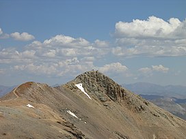
The Mosquito Range (elevation approximately 14,000 ft) is a high mountain range in the Rocky Mountains of central Colorado in the United States. The peaks of the range form a ridge running north–south for roughly 40 mi (64 km) from southern Summit County on the north end, then along the boundary between Lake and Park Counties. The ranges forms a high barrier separating the headwaters of the Arkansas River near Leadville from South Park and the headwaters of the South Platte River near Fairplay. The highest peak in the range is Mount Lincoln at an elevation of 14,286 ft. Other fourteeners in the range are Quandary Peak (14,272 ft), Mount Bross (14,172 ft), Mount Democrat (14,148 ft), and Mount Sherman (14,036 ft).
© MMXXIII Rich X Search. We shall prevail. All rights reserved. Rich X Search
