Back سد الموصل Arabic سد الموصل ARZ Sadd Şaddām CEB بەنداوی مووسڵ CKB Mosulská přehrada Czech Mosul-dæmningen Danish Mosul-Talsperre German Presa de Mosul Spanish سد موصل Persian Barrage de Mossoul French
| Mosul Dam | |
|---|---|
 | |
| Location | 45 mi north of Mosul, Nineveh Governorate, Iraq |
| Coordinates | 36°37′49″N 42°49′23″E / 36.63028°N 42.82306°E |
| Construction began | 25 January 1981 |
| Opening date | 7 July 1986 |
| Construction cost | US$1.5 billion |
| Operator(s) | Ministry of Water Resources (17 August 2014)[1] |
| Dam and spillways | |
| Type of dam | Embankment, earth fill clay core |
| Impounds | Tigris river |
| Height | 113 m (371 ft)[2] |
| Length | 3.4 km (2.1 mi) |
| Elevation at crest | 341 m (1,120 ft) |
| Width (crest) | 10 m (33 ft) |
| Spillways | 2 |
| Spillway type | Service: controlled chute Emergency: fuse plug ogee |
| Spillway capacity | Service: 13,000 m3/s (460,000 cu ft/s) Emergency: 4,000 m3/s (140,000 cu ft/s) |
| Reservoir | |
| Creates | Mosul dam lake |
| Total capacity | 11,100,000,000 m3 (9,000,000 acre⋅ft) |
| Active capacity | 8,100,000,000 m3 (6,600,000 acre⋅ft) |
| Inactive capacity | 2,950,000,000 m3 (2,390,000 acre⋅ft) |
| Normal elevation | 330 m (1,080 ft) |
| Power Station | |
| Commission date | Mosul 1: 1986 Mosul 2: 1985 Mosul 3: 1989 |
| Turbines | Mosul 1: 4 × 187.5 MW (251,400 hp) Francis type Mosul 2: 4 × 15.5 MW (20,800 hp) Kaplan type Mosul 3: 2 × 120 MW (161,000 hp) Francis pump turbine[3][4] |
| Installed capacity | 1,052 MW (1,411,000 hp) |
| Annual generation | 3,420 gigawatt-hours (12,310 TJ) |
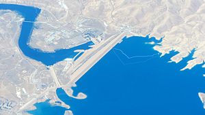
Mosul Dam (Arabic: سد الموصل), formerly known as Saddam Dam (سد صدام), is the largest dam in Iraq. It is located on the Tigris river in the western governorate of Nineveh, upstream of the city of Mosul. The dam serves to generate hydroelectricity and provide water for downstream irrigation. At full capacity, the structure holds about 11.1 cubic kilometres (2.7 cu mi) of water and provides electricity to the 1.7 million residents of Mosul.
The dam's main 750-megawatt (1,010,000 hp) power station contains four 187.5-megawatt (251,400 hp) Francis turbine–generators. A pumped-storage hydroelectricity power plant with a capacity of 250 megawatts (340,000 hp) and a run-of-the-river dam downstream with a 62-megawatt (83,000 hp) capacity also belong to the Mosul Dam scheme. It is the fourth largest dam in the Middle East, as measured by reserve capacity, capturing snowmelt from Turkey, some 70 miles (110 km) north.[5]
Built in the 1980s on a karst foundation, concerns over the dam's instability have led to major remediation and rehabilitation efforts since the 2003 U.S. invasion of Iraq.
- ^ "Kurdish forces 'retake Mosul dam' from IS militants". BBC News. 17 August 2014. Retrieved 17 August 2014.
- ^ "Iraqi Dam Assessments" (PDF). Iraq: United States Army, Corps of Engineers. 6 June 2003. Archived from the original (PDF) on 24 September 2015. Retrieved 27 February 2012.
- ^ "Mosul Multipurpose Development Iraq" (PDF). Poyry. Retrieved 27 February 2012.[permanent dead link]
- ^ "Electrical Power Stations in Iraq" (PDF). Arab Union of Electricity. Retrieved 27 February 2012.[permanent dead link]
- ^ Wright, Andrew G. (5 May 2003). "Iraqi Dam Has Experts On Edge Until Inspection Eases Fears". Engineering News-Record. Archived from the original on 8 August 2003.
© MMXXIII Rich X Search. We shall prevail. All rights reserved. Rich X Search
