Back جبل مونت بورجيس ARZ Mount Burgess (bukid sa Kanada, British Columbia) CEB Mont Burgess French Mount Burgess Hungarian Mount Burgess LLD Бёрджесс (гора) Russian Mount Burgess Swedish
| Mount Burgess | |
|---|---|
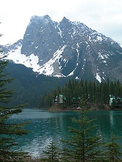
 Mount Burgess background and Emerald Lake foreground | |
| Highest point | |
| Elevation | 2,599 m (8,527 ft)[1][2] |
| Prominence | 418 m (1,371 ft)[3] |
| Parent peak | Mount Field (2642 m)[3] |
| Listing | Mountains of British Columbia |
| Coordinates | 51°25′12″N 116°30′19″W / 51.42000°N 116.50528°W[4] |
| Geography | |
| District | Kootenay Land District |
| Parent range | President Range |
| Topo map | NTS 82N7 Golden[4] |
| Climbing | |
| First ascent | 1892 by James J. McArthur and H. Tuzo[2][3] |
| Easiest route | Scramble[5] |
Mount Burgess, 2,599 m (8,527 ft), is a mountain in Yoho National Park and is part of the President Range in the Canadian Rockies. It is located in the southwest buttress of Burgess Pass in the Emerald River and Kicking Horse River Valleys.
- ^ Cite error: The named reference
GemTrek2001was invoked but never defined (see the help page). - ^ a b "Mount Burgess". cdnrockiesdatabases.ca. Retrieved 2019-08-20.
- ^ a b c "Mount Burgess". Bivouac.com. Retrieved 2008-12-22.
- ^ a b "Mount Burgess". BC Geographical Names. Retrieved 2010-11-13.
- ^ Cite error: The named reference
Kane1999was invoked but never defined (see the help page).
© MMXXIII Rich X Search. We shall prevail. All rights reserved. Rich X Search
