Back Damavand Afrikaans ዳማቫንድ Amharic جبل دماوند Arabic جبل دمافند ARZ Damavand AST Dəmavənd Azerbaijani دماوند AZB Дэмавенд Byelorussian Дамаванд BE-X-OLD Дамаванд Bulgarian
| Damavand | |
|---|---|
 | |
| Highest point | |
| Elevation | 5,671 m (18,606 ft)[1][2][disputed – discuss][3] |
| Prominence | 4,667 m (15,312 ft)[2][4] Ranked 12th |
| Parent peak | Mount Elbrus[5] |
| Listing | |
| Coordinates | 35°57′04″N 52°06′32″E / 35.951°N 52.109°E[6] |
| Naming | |
| Native name | دماوند |
| Geography | |
| Country | Iran |
| Province | Māzandarān |
| County | Amol |
| Parent range | Alborz – Mazandaran |
| Geology | |
| Mountain type | Stratovolcano |
| Last eruption | 5350 BC ± 200 years[6] |
| Climbing | |
| First ascent | 905 by Abu Dolaf Kazraji[7] |
| Easiest route | Hike |

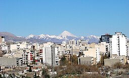
Mount Damavand (Persian: دماوند [dæmɒːvænd] ) is a dormant stratovolcano and is the highest peak in Iran and Western Asia, the highest volcano in Asia, and the 3rd highest volcano in the Eastern Hemisphere (after Mount Kilimanjaro and Mount Elbrus), at an elevation of 5,609 metres (18,402 ft).[8][9][a] Damāvand has a special place in Persian mythology and folklore. It is in the middle of the Alborz range, adjacent to Varārū, Sesang, Gol-e Zard, and Mīānrūd. It is near the southern coast of the Caspian Sea, in Amol County, Mazandaran Province, 66 km (41 mi) northeast of the city of Tehran.[10]


Mount Damāvand is the 12th most prominent peak in the world and the second most prominent in Asia after Mount Everest. It is part of the Volcanic Seven Summits mountaineering challenge.
- ^ Geography of Iran Archived 2015-01-17 at the Wayback Machine
- ^ a b "Kuh-e Damavand – Iran Ultra Prominence". peaklist.org. Retrieved 16 October 2011.
- ^ 2009 U.S. military topographic mapping gives 18,365 feet (5,598 meters) but states in the margin that all elevations are derived from SRTM. A summitpost map is based on the Persian language 1999 Iranian government 1:50,000 mapping which plots two 5620 contour circles, with a 5628 m spot height for the highest spot on the crater rim (WNW side) and 5626 m for the highest point on the southeast side (and a 5610 m spot height in the due north position.) This is supported by GPS evidence and SRTM data.
- ^ "Damavand, Iran". Peakbagger.com.
- ^ Pona, Georgia – Key col for Damavand peakbagger.com. Retrieved 29 January 2016
- ^ a b Cite error: The named reference
GVPwas invoked but never defined (see the help page). - ^ "SummitPost: Damavand". Retrieved 28 April 2010.
- ^ "Home". iranclimbingguide.com.
- ^ "Mountain Damavand". PersiaPort. Archived from the original on 5 July 2015. Retrieved 19 June 2015.
- ^ Microsoft Encarta World Atlas, 2001, Microsoft Corporation
Cite error: There are <ref group=lower-alpha> tags or {{efn}} templates on this page, but the references will not show without a {{reflist|group=lower-alpha}} template or {{notelist}} template (see the help page).
© MMXXIII Rich X Search. We shall prevail. All rights reserved. Rich X Search
