Back مونت هولي Arabic مونت هولى ARZ ماونت هالی، قوزئی کارولینا AZB Mount Holly (Carolina del Nord) Catalan Маунт-Голли (Къилбаседа Каролина) CE Mount Holly (lungsod) CEB Mount Holly, Gogledd Carolina Welsh Mount Holly (Carolina del Norte) Spanish Mount Holly (Ipar Carolina) Basque ماونت هالی، کارولینای شمالی Persian
Mount Holly, North Carolina | |
|---|---|
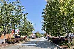
 Downtown Mount Holly | |
 Location of Mount Holly, North Carolina | |
| Coordinates: 35°18′51″N 81°00′28″W / 35.31417°N 81.00778°W | |
| Country | |
| State | |
| County | Gaston |
| Incorporated | March 11, 1879 |
| Government | |
| • Mayor | David Moore |
| Area | |
| • Total | 11.30 sq mi (29.26 km2) |
| • Land | 11.21 sq mi (29.05 km2) |
| • Water | 0.08 sq mi (0.21 km2) |
| Elevation | 627 ft (191 m) |
| Population (2020) | |
| • Total | 17,703 |
| • Density | 1,578.51/sq mi (609.46/km2) |
| Time zone | UTC-5 (Eastern (EST)) |
| • Summer (DST) | UTC-4 (Eastern (EDT)) |
| ZIP code |
|
| Area codes | |
| FIPS code | 37-44960[3] |
| GNIS feature ID | 2404319[2] |
| Website | www |
Mount Holly is a small suburban city in northeastern Gaston County, North Carolina, United States. The city is situated just west of the Catawba River, north of Interstate 85, south of North Carolina State Highway 16. The population was 17,703 at the 2020 census,[4] up from 13,656 in 2010.
- ^ "ArcGIS REST Services Directory". United States Census Bureau. Retrieved September 20, 2022.
- ^ a b U.S. Geological Survey Geographic Names Information System: Mount Holly, North Carolina
- ^ "U.S. Census website". United States Census Bureau. Archived from the original on July 9, 2021. Retrieved January 31, 2008.
- ^ "Geographic Identifiers: 2010 Demographic Profile Data (G001): Mount Holly city, North Carolina". U.S. Census Bureau, American Factfinder. Archived from the original on February 12, 2020. Retrieved October 27, 2013.
© MMXXIII Rich X Search. We shall prevail. All rights reserved. Rich X Search
