Back جبل وارننغ Arabic Mount Warning CEB Mount Warning German Mount Warning Finnish Mont Warning French Mount Warning Dutch Mount Warning Swedish
| Mount Warning | |
|---|---|
| Bundjalung: Wollumbin[1] | |
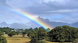
 Mount Warning with rainbow viewed from Murwillumbah High School Riverview Street carpark. | |
| Highest point | |
| Elevation | 1,159 m (3,802 ft)[2] |
| Prominence | 952 m (3,123 ft)[2] |
| Coordinates | 28°23′50″S 153°16′15″E / 28.39722°S 153.27083°E[3] |
| Geography | |
Location in New South Wales, Australia | |
| Location | Northern Rivers, New South Wales, Australia |
| Parent range | Tweed Range |
| Geology | |
| Age of rock | Over 23 million years |
| Mountain type | Volcanic plug |
| Last eruption | ~23 Ma |
| Climbing | |
| Easiest route | Walking track |
Mount Warning (Bundjalung: Wollumbin[1]), a mountain in the Tweed Range in the Northern Rivers region of New South Wales, Australia, was formed from a volcanic plug of the now-gone Tweed Volcano. The mountain is located 14 kilometres (9 mi) west-south-west of Murwillumbah, near the border between New South Wales and Queensland.[1][3] Lieutenant James Cook saw the mountain from the sea and named it Mount Warning.[3][4]
- ^ a b c "Wollumbin". Geographical Names Register (GNR) of NSW. Geographical Names Board of New South Wales. Retrieved 7 April 2009.
- ^ a b "Mount Warning, Australia". Peakbagger.com. Retrieved 12 May 2015.
- ^ a b c "Mount Warning". Geographical Names Register (GNR) of NSW. Geographical Names Board of New South Wales. Retrieved 7 April 2009.
- ^ Cite error: The named reference
Cookwas invoked but never defined (see the help page).
© MMXXIII Rich X Search. We shall prevail. All rights reserved. Rich X Search
