Back Mountcharles CEB Mountcharles Spanish Mountcharles Basque Tamhnach an tSalainn Irish Tamhnach an tSalainn GV Танталлон Russian Mountcharles Swedish
Mountcharles
Irish: Tamhnach an tSalainn | |
|---|---|
Village | |
 | |
| Coordinates: 54°39′N 8°12′W / 54.650°N 8.200°W | |
| Country | Ireland |
| Province | Ulster |
| County | County Donegal |
| Government | |
| • Dáil constituency | Donegal |
| Population | |
| • Total | 484 |
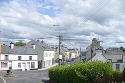
Mountcharles (Irish: Tamhnach an tSalainn)[2][3][4] is a village and townland (of 650 acres) in the south of County Donegal, Ireland. It lies 6 km from Donegal Town on the Killybegs road (N56). It is situated in the civil parish of Inver and the historic barony of Banagh.[5] The village's name is usually pronounced locally as 'Mount-char-liss'.
- ^ "Census 2016 Sapmap Area: Settlements Mountcharles". Central Statistics Office (Ireland). Retrieved 4 June 2018.
- ^ Placenames Database of Ireland: Mountcharles/Tamhnach an tSalainn
- ^ "TV Mountcharles". We Love Donegal. Retrieved 23 December 2015.
- ^ ""Tamhnach" translation in Irish English Dictionary Foclóir".
- ^ "Mountcharles". IreAtlas Townlands Database. Retrieved 6 May 2015.
© MMXXIII Rich X Search. We shall prevail. All rights reserved. Rich X Search
