Back مولتنوماه فالس ARZ Rhaeadr Multnomah Welsh Multnomah Falls German Multnomah Falls Spanish آبشار مولتنومه Persian Chutes de Multnomah French Մուլթնոմա ջրվեժ Armenian マルトノマ滝 Japanese Малтнома – Фолс сарқырамасы Kazakh Maltnomaho krioklys Lithuanian
| Multnomah Falls | |
|---|---|
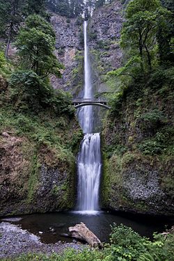
 Full view of both tiers of the falls | |
 | |
| Location | Columbia River Gorge, Multnomah County, Oregon, U.S. |
| Coordinates | 45°34′33″N 122°06′55″W / 45.57595°N 122.11536°W |
| Type | Tiered |
| Elevation | 627 ft (191 m) |
| Total height | 620 ft (189 m) |
| Number of drops | 2 |
| Longest drop | 542 ft (165 m) |
| Average width | 10 ft (3 m) |
| Watercourse | Multnomah Creek |
| Average flow rate | 150 cu ft/s (4.2 m3/s) |
| World height ranking | 434 |
Multnomah Falls is a waterfall located on Multnomah Creek in the Columbia River Gorge, east of Troutdale, between Corbett and Dodson, Oregon, United States. The waterfall is accessible from the Historic Columbia River Highway and Interstate 84. Spanning two tiers on basalt cliffs, it is the tallest waterfall in the state of Oregon at 620 ft (189 m) in height.[1] The Multnomah Creek Bridge, built in 1914, crosses below the falls, and is listed on the National Register of Historic Places.
The land surrounding the falls was developed by Simon Benson in the early-twentieth century, with a pathway, viewing bridge, and adjacent lodge being constructed in 1925. The Multnomah Falls Lodge and the surrounding footpaths at the falls were added to the National Register of Historic Places in 1981. Contemporarily, the state of Oregon maintains a switchback trail that ascends to a talus slope 100 feet (30 m) above the falls, and descends to an observation deck that overlooks the falls' edge. The falls attract over two million visitors each year,[2] making it the most-visited natural recreation site in the U.S. Pacific Northwest.[3]
© MMXXIII Rich X Search. We shall prevail. All rights reserved. Rich X Search