| Hendon | |
|---|---|
| Local Government District (1879–1894) Urban District (1894–1932) Municipal Borough (1932–1965) | |
 Hendon Town Hall | |
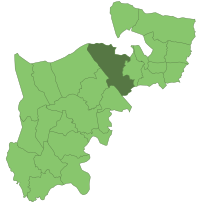
 Hendon within Middlesex in 1961 | |
| Area | |
| • 1894 | 8,382 acres (34 km2) |
| • 1965 | 10,369 acres (42 km2) |
| Population | |
| • 1901 | 22,450 |
| • 1961 | 151,843 |
| History | |
| • Created | 1879 |
| • Abolished | 1965 |
| • Succeeded by | London Borough of Barnet |
| Status | Urban district (1894-1932) Municipal borough (1932-1965) |
| Government | |
| • HQ | Hendon Town Hall |
| • Motto | Endeavour |
 Coat of Arms[1][2] | |
Hendon was an ancient parish of around 8,250 acres (33 km2) in Middlesex, on the border with Hertfordshire. As well as Hendon itself, the parish included Childs Hill, Golders Green and Mill Hill. In 1879 the parish was made a local government district. Such districts became urban districts in 1894. In 1931 the urban district absorbed the neighbouring parish of Edgware, and the following year the urban district was incorporated to become a municipal borough. The borough was abolished in 1965 when the area was transferred from Middlesex to Greater London and became part of the London Borough of Barnet.
- ^ "Hendon - Coat of arms (crest) of Hendon". Heraldry of the World. Retrieved 9 August 2022.
- ^ "Hendon Coat of Arms". Barnet Council. Retrieved 9 August 2022.
© MMXXIII Rich X Search. We shall prevail. All rights reserved. Rich X Search
